Physical and land use planning
Get a Quote for your project
Master plan video
Georole Planning team is engaged with some of the most complex and high-profile development projects. Importantly, we aim to provide the same first-class Planning service to clients large and small.
The Kenya’s ‘planning system’ remains complex, we anticipate the pitfalls and will help our clients navigate the planning process as smoothly as possible. The collaborative spirit among our Planning Team, other Professional Collaborators and the Authority in charge ensures that we apply the right expertise to the right projects and applying our collective experience and appropriate approach to solving often complex planning challenges and focusing on deliverable outcomes whilst minimising risk for the client.
We pride ourselves on impartial professional advice always in the best interests of our clients be they landowners, occupiers or investors.
We cover all aspects of urban Planning including:
- Project management and design team co-ordination to support planning application preparation
- Planning applications, all types of developments that require permission. Including:
- Construction/Building Permit
-
Change of Use, Extension of Use, Renewal of Lease, Extension of Lease
- Changing from Freehold to Leasehold and vice versa
- Approval of Subdivision scheme
- Consent for Subdivision /Transfer
- Site planning appraisals
- Local Plan monitoring and policy representations
- Conducting public sensitization and educating the public on proposed projects
- Stakeholder identification and analysis as well as organizing stakeholder workshops.
- Spatial planning
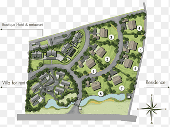
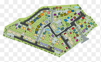
- Master planning e.g. for estates, community, institutions such like schools, hospitals, etc
- Schemes e.g. Settlement Schemes, Scheme Plans, subdivision schemest.c
- Local Physical & Land Use Development Plans
- Planning strategies and risk assessments g., Integrated Strategic Urban Development Plans.
- Pre-feasibility and Feasibility Studies
- Geo-spatial data collection & analysis
- Social Economic Survey & Data Analysis
- Site identification and land promotion through the local plan process
Featured images