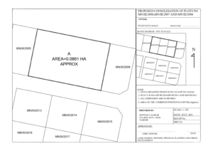
A consolidation survey is a combination of several land parcels into one. Once complete, the land is given a new legal description to correctly reflect the new parcel.
It entails re-mapping of two or more adjacent lots or parcels of land, combining them into one larger parcel. Once the survey work is completed, a map that indicates the new combined parcel of land will be reflected on the approved consolidation survey plan and marks the new legal boundary for the consolidated piece of land

The primary reason for a consolidation survey is to parcel off sections of land to meet specifications. As a result, these new legal descriptions must meet city and county standards. Once completed, they must then be filed by the property owner with the county for approval. The cost of the survey is different for each project. Examples that could affect the cost are included in the list below.
factors determining cost of consolidation survey
- The location, accessibility, and ruggedness of the parcel of land you want surveyed.
- The shape and size of the surveyed parcels of land.
- Seasonal variations in important features of the land such as leaf cover or ground markings.
- “Riparian Rights” or issues arising from properties along water
GeoRole Surveying, offers survey services in Kenya including that of consolidation and is ready to assist with your land surveying needs. Contact us today!


