by Georole Ltd | May 18, 2023 | physical and land use planning, environnment management
This article is a research project on challenges of upgrading urban slums conducted and its finding are discussed as well as recommendations on appropriate strategies and approach to be employed to solve the slum issue. The article also answers most questions about slums.
ABSTRACT
The rapid growth and expansion of slums needs more attention or else the increased development of informal settlements will be the dominant form of urbanization in most developing countries. Rapid urbanization and its related consequences have been difficult to handle and manage, particularly in countries like Kenya, India, Ghana, Nigeria, South Africa and Egypt. This report gives an overview of challenges of upgrading urban slums and informal settlements; case of Kwa Nyambura in Mtwapa informal settlements, Kilifi County. The report also constitutes study findings of a field research carried out in March and April of 2019 guided by these central questions: –
- What approach employed in upgrading Kwa Nyambura settlement and to what extent has it contributed to ensure Kwa Nyambura successfully upgraded?
- Who are the stakeholders and what role did they play in Kwa Nyambura slum upgrading?
- What are the main challenges encountered while upgrading Kwa Nyambura slum?
- What planning approaches would be appropriate for improving residential housing or upgrading urban slums?
The study employed secondary data from literature review for theoretical framework development and field study tools. The study employed case study design and the data was analyzed descriptively and presented in tables and figures.
Slum upgrading in Kwa Nyambura has various stakeholders including the UN-HABITAT, Community groups, Local Authorities of Kilifi and Mombasa, Local CBOs and donors, the Ministry of Lands, local business owners and the Ministry of Local Government (MoLG). Despite the establishment of an institutional framework for Kwa Nyambura improvement and prevention of informal settlements through the Kenya Slum Upgrading Programme and Kenya Informal Settlements Improvement Programme by the government, the implementation of Kwa Nyambura slum upgrading programme faces several challenges that include:-. Lack of cooperation from residents, lack of adequate space, competing and conflicting interests within different actors, corrupt contractors, lack of political will, low pace of development, and lack of ownership (tenure security) from residents.
It is in view of these challenges that the study recommends guidelines outlined in chapter five of this report for use in Kwa Nyambura slum upgrading programme specifically and any other similar set up generally.
Table of Contents
ABSTRACT. 5
LIST OF FIGURES. 11
LIST OF ABBREVIATIONS AND ACRONYMS. 13
CHAPTER ONE: INTRODUCTION.. 14
1.1 Background of the Study. 14
1.2 Statement of the problem.. 16
1.3 OBJECTIVES. 17
1.4 QUESTIONS. 17
1.5 ASSUMPTIONS. 17
1.6 JUSTIFICATION AND SIGNIFICANCE OF THE STUDY. 17
1.7 Scope of the study and its limitations. 18
1.8 Definitions of Key Terms. 18
CHAPTER TWO: LITERATURE REVIEW… 20
2.1 Growth of Slums in the World. 20
2.2 Historical development of Slums in Kenya. 21
2.3. Institutional arrangements for slum upgrading. 21
2.3.1 Kenya Vision 2030. 21
2.3.2 The Poverty Reduction Strategy Paper, 2005. 22
2.3.3 Kenya Slum Upgrading Programme. 22
2.3.4 National Slum Upgrading and Prevention Policy, 2012. 22
2.3.5 Kenya Informal Settlement Improvement Project. 23
2.4 Legal Framework. 23
2.4.1 Environmental Management and Co-ordination Act, 1999. 23
2.4.2 Physical Planning Act-Cap 286 of the laws of Kenya. 24
2.4.3 Water Act 2002. 24
2.4.4 Housing Act. 24
2.4.5 Government Lands Act. 24
Trust Lands Act. 24
2.4.7 The Constitution of Kenya. 24
2.5 Theory on Slum and Housing by Turner John F. 25
Figure 2 1: Conceptual framework. 27
CHAPTER THREE: RESEARCH METHODOLOGY. 28
3.0 Introduction. 28
3.1 Area of study. 28
3.2 Research design. 28
3.3 Target population. 29
3.4 Sampling design. 29
3.5 Data collection instruments and techniques. 30
3.5.1 Questionnaire. 30
3.5.2 Document Review.. 30
3.5.3 Observation schedule and photography. 30
3.5.4 Structured interviews. 31
3.5.5 Focus group discussions. 31
3.6 Data Analysis. 31
CHAPTER FOUR: FIELD STUDY, DATA ANALYSIS AND PRESENTATION.. 32
4.1 Introduction. 32
4.2 Background information. 32
4.2.1 Age distribution of respondents. 32
The Age of the respondent. 32
4.2.2 Gender of respondents. 33
Respondents Gender. 33
4.2.3 Level of education. 34
4.2.4 Duration of stay in Kwa Nyambura. 35
Period Stayed at Kwa Nyambura (Years). 35
4.3 Property ownership. 36
House ownership. 36
4.4 Security of tenure. 37
Ownership document. 37
4.5 House rents per month. 38
Rent payed out per month. 38
4.6 Building materials. 39
4.7 Number of rooms per household. 40
4.8 Access to Basic Services. 42
4.8.1 Solid waste disposal 42
4.8.2 Human waste disposal 43
4.8.3 Water supply. 43
4.8.4 Roads. 44
4.8.5 Healthcare facilities. 46
Accessibility of healthcare services. 47
4.8.6 Educational facilities. 49
4.8.7 Neighbourhood nature of security. 51
CHAPTER FIVE: SUMMARY OF FINDINGS, CONCLUSIONS AND RECOMMENDATIONS. 52
5.0 Introduction. 52
5.1 Summary of Finding. 52
5.2 Conclusion. 54
5.3 Recommendations. 55
References. 56
APPENDICES. 58
APPENDIX I 58
APPENDIX II 64
APPENDIX III 67
APPENDIX IV.. 68
LIST OF FIGURES
Figure 4 1: Age of respondent 33
Figure 4 2: Gender of the respondent 34
Figure 4 3: Level of education. 35
Figure 4 4: Duration of stay in Kwa Nyambura. 36
Figure 4 5: House ownership. 37
Figure 4 6: Roofing materials. 39
Figure 4.7: Figure 4 7: Walling materials. 40
Figure 4 8: Flooring materials. 40
Figure 4 9: Number of rooms per structure unit 41
Figure 4 10: Mixed development structures. 41
Figure 4 11: Solid waste disposal 42
Figure 4 12: Water accessibility. 44
Figure 4 13: Accessibility of roads. 44
Figure 4 14: Narrow and irregular roads. 45
Figure 4 15: Muddy roads. 46
Figure 4 16: Health progress over the past few years. 47
Figure 4 17: Jambo medical centre; private healthcare facility. 48
Figure 4 18: Public healthcare facility. 48
Figure 4 19: The Greenpark healthcare; private facility. 49
Figure 4 20 Mtwapa academy; Private facility. 50
Figure 4 21: Jambo Jipya schools; private facility. 50
Figure 4 22: Neighbourhood security. 51
LIST OF TABLES
Table 4. 1: Age bracket of respondents. 32
Table 4. 2: Gender of the respondent 33
Table 4. 3: Education level of the respondent 34
Table 4. 4: Duration of staying in Kwa Nyambura. 36
Table 4. 5: House ownership. 36
Table 4. 6: Ownership document 37
Table 4. 7: Rent paid out per month. 38
Table 4. 8: Human waste disposal 43
Table 4. 9: Accessibility of healthcare services. 47
Table 5. 1: Stakeholders and their roles. 53
LIST OF ABBREVIATIONS AND ACRONYMS
AFD French Agency for Development
EMCA Environmental Management and Co-ordination Act
KENSUP Kenya Slum Upgrading Programme
KISIP Kenya Informal Settlement Improvement Project
MoLG Ministry of Local Government
NEMA National Environmental Management Authority
NGOs Non-Governmental Organisations
SIDA Swedish International Development Agency
UN United Nations
UN-HABITAT United Nations Human Settlements Programme
CHAPTER ONE: INTRODUCTION
1.1 Background of the Study
Kenya has witnessed rapid urbanization process for almost six decades now thus emerging as a major development planning issue. This has resulted to a great challenge that rapid urbanization in Kenya has not been accompanied by the necessary growth of infrastructure and services and industrialization. Of particular concern is the inadequate supply of housing for a majority of the urban dwellers that are mainly urban low-income groups, providing themselves with substandard housing in unplanned settlements. As a result, more urban dwellers in Kenya live in poverty and reside in overcrowded slums that lack basic amenities to sustain a minimum level of living.
In 1962, it was estimated that only one Kenyan out of every 12 lived in urban centres. By the year 1999, the proportion of the urban population had increased to 34.5 per cent which is close to 10 million people implying that one out of every three Kenyans lived in urban areas. By now, the level of urbanization is estimated to have reached 44.5% with an estimated 16.5 million people living in urban areas and eventually percentage is set to reach 54% by 2030 with about 23.6 million people living in urban areas (Kenya Vision 2030). This percentage was expected to increase to 50% by the year 2015. This rate of urbanization and the inability of our urban economies to match the pace have contributed immensely to the proliferation of slums and informal settlements.
UN-Habitat has initiated Participatory Slum Upgrading Programme (PSUP). Mtwapa is part of the slum upgrading project managed by UN-Habitat. The population of Mtwapa is estimated to be 50,000 and half of the town population live in informal settlements. Mtwapa consists eleven informal settlements which includes the following Mzambarauni, Makadara, Mtomodoni, Four Farm, Kwa Nyambura, Kwa Gowa, Kanamai Majengo, Maweni, Kwa Mavitswa/ Kwa Samira, Soweto and Mwando Wa Panya. The Participatory Slum Upgrading Program (PSUP) aims at improving living standards of slum dwellers in Mtwapa by addressing the five depravations of slums namely the lack of access to safe drinking water, access to improved sanitation, overcrowding, durability of living structures and security of tenure.
The national government of Kenya realized the trend and took a step to reverse it. It partnered with the local governments (currently county governments) as well as involving stakeholders in initiating the Kenya Informal Settlement Improvement Project (KISIP) in the year 2011and the Kenya Slum Upgrading Programme (KENSUP) in the year 2004. The programs have a common goal of improving living conditions in slums and informal settlements. This entails improving sanitation, providing security of tenure, improvement in sufficient living area and improving drinking water sources such like pipe water in dwellings, community pipe and boreholes.
1.2 Statement of the problem
The issue of slums is a global concern as indicated in the United Nations Millennium Declaration and subsequent identification of new development priorities by the international community. Due to increasing numbers of urban slum dwellers, governments adopted a specific target on slums as highlighted in the Millennium Development Goal (MDG) 7, Target 11, whose aims was to significantly improve the lives of at least 100 million slum dwellers by the year 2020.
There have been many attempts to respond to the issue of urban slums basing on a belief that provision of improved housing and related services through slum upgrading and physical eradication of slums would solve the slum problem. Solutions based on this premise have failed to address the main underlying causes of slums (UN-Habitat, 2003).
Despite the fact that Kenya has laid efforts in addressing the slum issue through various policy such as housing policy and land policy as well as programs such as Kenya Informal Settlement Improvement Project (KISIP) and Kenya Slum Upgrading Programme (KENSUP) the impacts of these interventions are yet to be realized. The rate at which slums and informal settlements emerging and growing in urban areas needs more attention. Previous policies which have sought to improve housing, infrastructure and physical environmental conditions have not adequately addressed challenges of low-income housing in informal settlements. The executive director of UN-Habitat, Anna Tibaijuka, states categorically that we should not continue trying methods which have not produced the desired improvements and changes in informal settlements. We should instead adopt new methods which may have a lasting solution to this problem which cannot just be wished away.
Since the slum upgrading experience in Kenya has not been a bed of roses, the study intended to ascertain which challenges have hindered the uptake; and then recommended appropriate approaches towards addressing the identified slum upgrading challenges in the study area.
1.3 Objectives
The main purpose of the study was to determine the challenges in upgrading urban slums by taking a case of Kwa Nyambura in Mtwapa, Kilifi County, Kenya.
Specific objectives
- To determine the approach employed in upgrading Kwa Nyambura settlement and its level of success to the program.
- To investigate stakeholders involved and their roles in upgrading Kwa Nyambura informal settlement.;
- To study slum upgrading experience in the area of study.
- To suggest appropriate approaches for urban slum upgrading that are sustainable.
1.4 Questions
- What approach employed in upgrading Kwa Nyambura settlement and to what extent has it contributed to ensure Kwa Nyambura successfully upgraded?
- Who are the stakeholders and what role did they play in Kwa Nyambura slum upgrading?
- What are the main challenges encountered while upgrading Kwa Nyambura slum?
- What planning approaches would be appropriate for improving residential housing or upgrading urban slums?
1.5 Assumptions
- The approach used has not met the housing standards to the beneficiaries of the slum upgrading programme.
- Service provision in urban slums underwent upgrading is still poor. For example; inadequate security, low infrastructure provision and inadequate water supply.
1.6 Justification and Significance of the Study
The slum issue has been a challenge to cities and major towns of many countries Kenya being one of them. Consequently, efforts to address the slums and informal settlement challenges have been left to planners and the planning authorities. In the process of trying to address this challenge, various approaches to slum upgrading have been tried with an aim of improving the livelihood in slum settlements and most importantly preventing proliferation of slum settlements. The attempted approaches had challenges and impacts thus indicating that Government and other stakeholders are yet to demonstrate an approach that effectively and sustainably address issues of slums in urban areas.
Addressing the challenges of slum upgrading for urban informal settlements will not only contribute towards improving the livelihoods of the slum dwellers but will also solve the socio-economic issues. The failure of slum upgrading would mean continued suffering of the vulnerable groups in the slum. The study identified the root causes of these challenges and proposed appropriate recommendations upgrading programme in their approaches and interventions and fill the gaps.
1.7 Scope of the Study and its Limitations
Thematically the study focused mainly on residential housing unit, and the study examined the existing challenges of upgrading urban slums and informal settlements. The researcher assessed housing unite condition, exploring the major factors for residential housing problem in the area, and suggested measures that will help to improve the accessibility and affordability of standard housing to the existing residence and the ever growing population in the urban Mtwapa. Spatially the study is limited to Kwa Nyambura area of Mtwapa in Kilifi County.
1.8 Definitions of Key Terms
Slum: at its simplest is a heavily populated urban area characterized by sub-standard housing and squatter.
UN-Habitat defines a slum settlement as one that lack one or more of the following:
- Durable housing of a permanent nature that protect against extreme condition.
- Sufficient living space at least not more than two people sharing the same room.
- Easy access to safe water in sufficient amount and at affordable price.
- Access to adequate sanitation in the form of private/public toilet shared by a reasonable number of people.
- Security of tenure.
Informal settlement: is a settlement that results from illegal urban development process including unregulated sub-division of land and unauthorized construction of houses.
Upgrading: Refers to an effort to improve living conditions in particular urban areas characterized by poor-quality housing and inadequate infrastructure and service delivery (Hardoy, Mitlin, Satterthwaite, 2001: 222).
Slum Upgrading: is a basic improvement of physical structures to a holistic addressing of social, economic, and infrastructure needs. Slum upgrading refers to the improvement of slum households’ living conditions which can be achieved through better water supply, sanitation and other basic urban services; housing improvements; and provision of tenure security.
According to Syagga, 2011. Slum Upgrading refers to a process of intervention for economic, organizational and environmental improvement to an existing human settlement undertaken collectively among citizens, community groups, governments (national/local) and any other development partners (Non-governmental, multi-lateral/bilateral organisations). Although the reasons for slum upgrading may vary from place to place, the main push factors have included the demand for affordable tenure options, environmental health considerations and poverty reduction.
Stakeholders: -persons, groups or institutions with interests in project or programme (McElroy & Mills: 2000)
CHAPTER TWO: LITERATURE REVIEW
2.1 Growth of Slums in the World
The rapid growth of population and its concentration in cities around the world has constituted a crucial element that is affecting the long-term outlook of humanity. Urbanization has led to the growth of slums, squatter and informal housing all around the rapidly expanding cities and towns of the developing world. According to UH-HABITAT (2003) urban populations have increased explosively in the past 50 years and it is estimated that this increase will continue for the next 30 years. This shall be as result of population increase within the cities and which shall be brought about by an increase in the number of people born in the cities and due to increased rural to urban migrations. It is envisaged that the increased growth in population (the urban labour force) will not be met with a similar rate of creation of formal sector urban jobs and therefore majority of these new residents will eke out an informal living thus ending up in the slums (UN-HABITAT, 2003).
During the first United Nations Conference on Human Settlements in 1976, the world population was estimated to be just over 3.5 billion people. Two decades latter at the second United Nations Conference on Human Settlements the world population stood at 6 billion. The world’s urban population had doubled in only two decades. UN-HABITAT (2003) noted that developing world, which was been predominantly rural, was rapidly turning urban. In 1950, only 18 % of people in developing countries lived in cities while in 2000, the proportion was 40 %, and by 2030, the developing world is predicted to be 56% urban. It is envisaged that future urban growth in developing countries will be absorbed by urban centres, which have a high average annual urban population growth rate of 2.3 per cent, in contrast to the developed world’s rate of 0.4 per cent.
Estimation by Davis (2004), indicates that there were more 250,000 slums in the world. In the developed world, they are noted to have been in existence since the industrial revolution and currently over 6% of the population in these countries live in slums while China and India together house 37% of the world’s slums. According to Davis (2004), the five great metropolises of South Asia (Karachi, Mumbai, Delhi, Kolkata and Dhaka) are considered to be home to over 15,000 distinct slum communities with a total population of more than 20 million. UN-HABITAT (2003) reveal that over 90 per cent of slum dwellers are in the developing world with sub-Saharan Africa, where urbanization was seen to be virtually synonymous with slum growth, has 72% of its urban population living in slums.
In Delhi as highlighted by Prodipto and Shangon (1995), planners complained about the situation of ‘slums within slums’ as squatters took over the small open spaces of the peripheral resettlement colonies into which the old urban poor were brutally removed in the mid-1970s while in Cairo and Phnom Penh urban dwellers were squatting or renting space on rooftops thus creating slums in the air.
2.2 Historical development of Slums in Kenya
The issue of slum in Kenya is partly a legacy of the colonial policy of racial segregation. During the colonial era, Kenya witnessed a large-scale government sanctioned spatial segregation based on race and reinforced by planning laws and exclusionary zoning regulations (Olima, 2001). Urban planning in Nairobi was based on government-sanctioned population segregation, which resulted to separate enclaves for Africans, Asians and Europeans. The slums developed mainly because of unbalanced allocation of housing and infrastructural resources needed by the separated racial groups (Black Man’s land, Nation TV, 03-03-2009).
The perception that slums, squatters and informal settlements are illegal can be traced back to the colonial period in Kenya. Originally, unauthorized settlements sprang up because Africans were displaced by the arrival of European settlers. The Europeans expropriated large tracts of land around Nairobi and did not allow Africans to enter the city unless they had a permit (Mitullah, 2003).
2.3. Institutional arrangements for slum upgrading
2.3.1 Kenya Vision 2030
The aim of Kenya Vision 2030 is to provide the citizens with adequate and decent housing in a sustainable environment. Unplanned informal settlements pose a serious challenge to the socio-economic development of the country, which includes Overcrowding, lack of adequate sanitation and pollution causing serious health risks to residents.
Kenya’s urban areas have over the years suffered from poor planning, which has resulted in the proliferation of informal settlements with poor housing and little or no infrastructure services. Among the Vision 2030 flagship project is the principle vehicle for achieving housing and urbanization is installing physical and social infrastructure in slums in 20 urban areas to formalize slums, permit construction of permanent houses and attract private sectors in investment.
2.3.2 The Poverty Reduction Strategy Paper, 2005
According to the Poverty Reduction Strategy Paper (2005), implementation of slum upgrading, has been identified as one of the program to address poverty by targeting the poor communities. The slum-upgrading programme should improve the living conditions of millions of urban poor that live in urban slums by improving accessibility to sufficient quality water and sanitation, road, energy and housing infrastructure.
2.3.3 Kenya Slum Upgrading Programme
KENSUP is an initiative that draws on the expertise of a wide variety of partners in order to redress the issue of slums. The Government of Kenya executes and manages the programme while the Ministry of Housing and the relevant local authorities implement it. Civil society partners, participating local communities and the private sector complement and support their efforts.
The primary goals of KENSUP is to improve the livelihood of people working and living in the informal settlements in the urban areas of Kenya, to reduce poverty and fulfill the Millennium Development Goal 7 Target 11 – to improve the lives of 100 million slum dwellers by the year 2020. The vision of the programme is to facilitate improved and sustainable urban living environments in Kenya while the mission is to develop and implement policies, programmes and strategies to facilitate reduction and prevention of slums in Kenya (GoK: 2004).
2.3.4 National Slum Upgrading and Prevention Policy, 2012
In the year 2012, the Government through the Ministry of Housing initiated the process of developing the National Slum Upgrading and Prevention Policy. The policy aims to transform slums and informal settlements into more livable environments. In order the policy to realize its aim, the Government recognizes and undertakes to collaborate with all actors and stakeholders to ensure that the process is participative, all-inclusive and compliant with the Kenya Constitution (2010).
2.3.5 Kenya Informal Settlement Improvement Project
The Government of Kenya in collaboration with the World Bank, SIDA and French Agency for Development (AFD) in June 2011, started the initiative Kenya Informal Settlement Improvement Project (KISIP) that focuses on improving living conditions in existing informal settlements by investing in infrastructure and strengthening tenure security.
KISIP also support the Government of Kenya in planning for future urban growth in a manner that prevents the emergence of new slums. The project comprises four components namely:-
- Institutional strengthening and programme management of the Ministry of Housing, Ministry of Lands and the participating Local Authorities;
- Enhancing tenure security
- Investing in infrastructure and service delivery: The Government will invest in roads, bicycle paths, pedestrian walkways, street and security lights, waste management, water drainage, sanitation, green spaces, platforms etc. in the informal settlement spaces and
- Planning for urban growth.
The goal of this initiative is to take measures that will reduce or prevent slums (Muraguri in IFRA: pg. 121).
2.4 Legal Framework
2.4.1 Environmental Management and Co-ordination Act, 1999
Under this act, NEMA was established with the responsibility of ensuring a clean and healthy environment. The Act prohibits the discharge of any poison, toxic, noxious or obstructing matter, radioactive waste or other pollutants or dumping into the aquatic environment.
EMCA, 1999 has played responsibilities of provision of housing and infrastructure services to the local authorities and emphasize on the need to maintain a clean environment that is pollution free. Therefore, the framework will provide for sustainable use of land in Mtwapa informal settlements thus Kwa Nyambura to ensure a livable environment.
2.4.2 Physical Planning Act-Cap 286 of the laws of Kenya
It vests powers on local government authorities to ensure orderly development, regulate zoning, approve development plans, control and prohibit the subdivision of land into small and un-economic sizes. Any developments to be carried out in Kwa Nyambura ought to undergo scrutiny by the council for approval before any work commences.
2.4.3 Water Act 2002
This act provides for the sustainable management, conservation, use, control of water resources and for the acquisition and regulation of rights to use water, including the regulation and management of water supply and sewerage services. The water sources in the study area should be protected from pollution and sewerage works should be done in accordance to this law.
2.4.4 Housing Act
This act was reviewed through the draft-housing bill of 2006. It provides for the effective co-ordination, regulation, guidance and monitoring of housing and settlement sector in the country for the establishment of an authority and fund for the provision of housing and other purposes.
2.4.5 Government Lands Act
The act provides for the conveyance of land interests and rights to be done following the English system by way of deed under seal.
2.4.6 Trust Lands Act
This act provides for the administration of trust lands. It states that trust land is to be administered by the commissioner of lands for and on behalf of the council vested with the land. Leases and licenses may be granted over trust land by a council with the same subject to payment of acceptable fees and royalties between a council and the licensee/lease.
2.4.7 The Constitution of Kenya
The Constitution vests development of a housing policy for the Country in the hands of the National Government while provision of housing is left to individual Counties.
Section 43 part 1(b) states that everyone has the right to accessible and adequate housing, and to reasonable standards of sanitation.
Section 44 (4) of the Constitution of Kenya stipulates that Public land shall not be disposed of or otherwise used except in terms of an Act of Parliament specifying the nature and terms of that disposal or use.
2.5 Theory on Slum and Housing by Turner John F.
The theory describes housing in two ways; Housing as a noun and housing as a verb. In defining housing as a noun, it refers to the physical structure that is house as a commodity whereas housing as a verb focuses on the universal activity of housing that is on-going process and the role of housing within the context of the household’s broader livelihood.
Turner emphasize on housing as a verb rather than on the material side. He observes that a squatter can be considered as housing not in terms of what it is but in terms of what it does. This observation becomes relevant in developing countries where resources, especially financial, are extremely limited and the dwellers are in dire poverty. Turner (1976) argues that the important thing about housing is not “what it is but what it does in people’s lives and advocates that the value of slums be measured not in terms of how well it conforms to the image of the dwellers standards, but rather it be measured in terms of how well the structure serves its inhabitants.
According to Tisong (2011) by citing Turner (1976) noted that for slum households whose building activities are not regulated by exogenous criteria, the proposition such that, households if given the autonomy to design, build, and manage the maintenance process; prospective households will be able to make their own arrangements for accommodation by supplementing their respective means of income by personal and local monetary resources such as their imagination, intuitiveness and capacity to use irregular sites, locally available building materials and tools, organizational capacities through self-help initiatives.
Turner (1976) derives his theory by contrasting housing that emanate from a decentralized decision process where the occupants have the authority and that which results from a process where a large centralized authority controls major decisions. Turner substantiate his theory by observing the self-help housing process in slums and squatter settlements and that of public housing programmes which produce large scale standardization (Turner, 1976). In conclusion, turner points out that, when tenure of property is secured and individual households have the authority to control major decisions regards their accommodation arrangements with respect to standards, location and tenure, both the process and the environment produced are economically viable as well as will stimulate the well-being of the residents which are necessary conditions to propel an orderly urban growth (Turner and Goetz, 1967).
The researcher agrees with Turner’s approach of the view that the successful provision of infrastructural services in slums is relevant to urban development. It is in seeking to address this, that the researcher takes a look at the challenges of upgrading urban slums with a view of proposing appropriate approaches for urban slum upgrading that are sustainable.
Figure 2 1: Conceptual framework
| APPROACHES FOR URBAN SLUM UPGRADING
Participatory Approach, Stakeholders Approach |
| CHARACTERISTICS OF SLUMS
Lack of basic infrastructure and services, sub-standard housing, overcrowding and high density, unhealthy living conditions and hazardous locations and finally, poverty and social exclusion |
| CHALLENGES OF UPGRADING URBAN SLUMS
Social segregation, Insecurity of land tenure, Lack of political will, Slum dwellers’ ignorance, lack of knowledge and skills to cope with challenge |
| FACTORS THAT LEAD TO SLUM SETTLEMENTS
Rapid urbanization, Poor planning regulations, bad governance, Poverty, Dysfunctional land markets and failed policies |
| SLUM IMPROVEMENT
Better living conditions, better housing, better provision of social infrastructure, security of tenure, economic empowerment. |
CHAPTER THREE: RESEARCH METHODOLOGY
3.0 Introduction
Research methodology refers to specific procedures or techniques used to identify, select, process, and analyze information about a topic. Therefore, in this section the researcher focused on research design, the target population, sampling design, data collection instruments and techniques, and data analysis procedures.
3.1 Area of study
The study area was Kwa Nyambura in Mtwapa informal settlements, Kilifi. There are eleven villages that constitute Mtwapa informal settlements which include Mzambarauni, Makadara, Mtomodoni, Four Farm, Kwa Nyambura, Kwa Gowa, Kanamai Majengo, Maweni, Kwa Mavitswa/ Kwa Samira, Soweto and Mwando Wa Panya.
The kwa Nyambura settlement straddles the Malindi Road. It borders the old ferry area to the east and Mtwapa Ruins to the west. It is located to the immediate west of Mtwapa. It has an area of 25 ha and a population of 7550 inhabitant.
Mtwapa lies about 15 Kilometers North East of Mombasa Town along Malindi road. It extends from the bridge to about 1km past Majengo. It lies between Northing 9562750 and Easting 577250 and Northing 9570500 and Easting 587500 with the highest and lowest points at Mtepeni (56m) and the area along the creek and oceanfront (2m) above sea level respectively.
3.2 Research design
Borg and Gall (1989), defined research design as a logical and valuable way of looking at the world. This study applied both quantitative and qualitative in order to offset the weaknesses as well as draw on the strengths of both methods since they have different merits and demerits as explained by Bryman, (2006).
According to Creswell (2003), use of quantitative and qualitative help in understanding complex data and give more complete and comprehensive account of the enquiry. The quantitative and qualitative data wias collected with equal priorities and the results of the two methods was integrated during interpretation phase (Creswell, 2003).
In reference to Bryman (2006) and Davies (2003) allows any unexpected results from any of the methods to be explained through findings generated and hence giving a more complete understanding.
3.3 Target population
A population is a complete set of individual cases or objects with some common observable characteristics (Mugenda, 1999). The research targets Kwa Nyambura an informal settlement in Mtwapa, Kilifi County. The settlement has an estimated population of 7550 inhabitants.
Accordingly, Mugenda & Mugenda (2003) states that it is impractical to select a representative sample from the target; thus a sample was drawn from an ‘accessible population’ which is more narrowly defined and manageable. Despite the high likelihood of losing the generalizability of the results, ‘population validity’ was used which is a way of establishing that the accessible population is in itself representative of the target population.
3.4 Sampling design
Kwa Nyambura settlement has an estimated population of 7550 inhabitants. Therefore, it was impossible to study the entire population even though ideally one wanted to. For the study to be successful without engaging the entire population the researcher had to settle for a sample. By referencing Black and Champion (1976), sample is a portion of elements taken from a population, which is considered representative of the population.
To determine a sample size the researcher proposed to adopt Slovene’s formula which is computed as n=N/(1+Ne^2). Whereas:
- n= number of samples
- N= total population
- e= error margin/margin of error
For the purpose of the research project, the researcher chose confidence level to be 90%, which gave an alpha level of 0.1.
Therefore, n=7550/ (1+7550*0.1^2)
n=98.6928105
Since a fraction of a person cannot be sampled, it is recommended to round off the answer to a whole number.
98.6928105 is rounded of to 99
3.5 Data collection instruments and techniques
For the purpose of this research, and in order to achieve the objectives different methods were employed to collect both quantitative and qualitative data. The sources of data collection included primary and secondary data sources.
Primary data was collected through the following instruments; questionnaire, interview schedule, observation and focus group discussions. Whereas secondary data was gathered by reviewing documents such like text books and journals with relevant information about the study.
3.5.1 Questionnaire
In reference to Cohen (1989), a questionnaire is a self-reported instrument used to gather information pertaining variables of interests to an investigation. In this research study structured questionnaires were used to collect primary data from households of the study area (Kwa Nyambura settlement). The researcher prepared questionnaires with both open and close-ended questions and administered them through a random sampling technique.
3.5.2 Document Review
For the purpose of the study it was important for the researcher to review text books, reports, published and unpublished works, and also search information from websites.
3.5.3 Observation schedule and photography
This method was applied in order to acquire data on aspects of residents’ livelihoods. The physical environment of Kwa Nyambura settlement was observed and noted down the information as well as captured photographs pertaining the issue. This included housing structure, water provision, sewerage, electricity, and road network and drainage system.
3.5.4 Structured interviews
The researcher chose to employ this technique of schedule interviews in order to enable the study apply both open and close ended questions. The information was collected through personal structured interviews that involved a set of questions. The interview was carried out with the target informants who are stakeholders and played a role in slum upgrading or development. For example the government agencies and NGOs.
The researcher preferred face to face interviews over telephone or computer assisted personal interviewing. This is because face to face interview allowed the researcher to establish rapport with potential subjects and gain their cooperation.
3.5.5 Focus group discussions.
The study applied this method to gather information more particularly on land tenure and roles of participants of Kwa Nyambura upgrading program. This was achieved through holding discussions with Kwa Nyambura residents, elders of the settlement, government representatives such like sub chiefs, chiefs sub county officers (District Officer) and other officials in the field of housing and infrastructure such as town council and the municipal council.
3.6 Data Analysis.
According to Miles and Huberman (1994), data analysis is the process of systemically searching and arranging the raw data, with aim of increasing one’s own understanding of the data. Miles and Huberman also suggested that a research should consist of five phases and that is data collection, data reduction, data display, conclusion drawing and verifying findings.
Therefore, collected data was checked, edited, and computer coded to decrease the amount of data obtained into away that was more suitable for analysis. Data was analyzed by the use of statistical package for social science programme (SPSS). The analyzed data then was summarized into frequencies and percentages and presented in tables, bar graphs, pie charts and figures.
The gathered qualitative data was analyzed by the use of content analysis procedures. Discussion of the results was done and created basis for the research findings, conclusion and recommendation. Finally, the qualitative data was presented by the use of descriptive narratives, notes and photographs.
CHAPTER FOUR: FIELD STUDY, DATA ANALYSIS AND PRESENTATION
4.1 Introduction
The chapter contains field study, data analysis and presentation. The study findings have been discussed in relation to the main objective of the study and specific objectives. The study findings are based on information obtained from data collected through various research instruments, which included questionnaires targeting all the households in Kwa Nyambura, focus group discussions, observation schedule, and interview schedule with key informants and through document analysis. The quantitative data was analyzed using descriptive statistics and was presented in the form of tables, percentages, graphs and charts.
4.2 Background information
4.2.1 Age distribution of respondents
From the findings of the study and as indicated in the table below most of the respondents in this study were between the age brackets of 36 to 55 years who were 47 in total (47.5%) while those between 18 to 35 years were 41 which is 41.4% of the participating respondents and those above 55 years were 11 (11.1%).
The Age of the respondent
|
|
Frequency |
Percent |
Valid Percent |
Cumulative Percent |
| Valid |
18-35 |
41 |
41.4 |
41.4 |
41.4 |
| 36-55 |
47 |
47.5 |
47.5 |
88.9 |
| >55 |
11 |
11.1 |
11.1 |
100.0 |
| Total |
99 |
100.0 |
100.0 |
|
Table 4. 1: Age bracket of respondents
Figure 4 1: Age of respondent
4.2.2 Gender of respondents
Of the household respondents that participated in this study, 69.7% were males while 30.3% were females as indicated in the table below.
Respondents Gender
|
|
Frequency |
Percent |
Valid Percent |
Cumulative Percent |
| Valid |
Male |
69 |
69.7 |
69.7 |
69.7 |
| Female |
30 |
30.3 |
30.3 |
100.0 |
| Total |
99 |
100.0 |
100.0 |
|
Table 4. 2: Gender of the respondent
Figure 4 2: Gender of the respondent
4.2.3 Level of education
The literacy level of the respondents revealed that most of them, 59.6%, had only basic education i.e. up to primary level with 4.0% having no education at all. Those who had made it to secondary level were 35.4% where those made it to tertiary 1%.
|
|
|
Frequency |
Percent |
Valid Percent |
Cumulative Percent |
| Valid |
None |
4 |
4.0 |
4.0 |
4.0 |
| Primary |
59 |
59.6 |
59.6 |
63.6 |
| Secondary |
35 |
35.4 |
35.4 |
99.0 |
| Tertiary |
1 |
1.0 |
1.0 |
100.0 |
| Total |
99 |
100.0 |
100.0 |
|
Table 4. 3: Education level of the respondent
Figure 4 3: Level of education
Sociological Studies indicate the existence of a negative relationship between poverty and education. This is because the greater the degree of education of individuals/families, the likelihood of poverty declines.
In most cases, income and educational status tends to move together in the same direction. With improvement in the level of education one is better placed in terms of income generation and therefore enhancing one’s own purchasing power thus improving ones standard of living
4.2.4 Duration of stay in Kwa Nyambura
Pertaining to the duration of stay in Kwa Nyambura by the respondents, the study findings indicate that 12 (12.1%); 42 (42.4%); and 45(45.5%) of the respondents had stayed in Kwa Nyambura settlement for less than 5 years; from 6 to10 years; and over 10 years correspondingly as presented in table below
Period Stayed at Kwa Nyambura (Years)
|
|
Frequency |
Percent |
Valid Percent |
Cumulative Percent |
| Valid |
<5 |
12 |
12.1 |
12.1 |
12.1 |
| 6-10 |
42 |
42.4 |
42.4 |
54.5 |
| >10 |
45 |
45.5 |
45.5 |
100.0 |
| Total |
99 |
100.0 |
100.0 |
|
Table 4. 4: Duration of staying in Kwa Nyambura

Figure 4 4: Duration of stay in Kwa Nyambura
4.3 Property ownership
In this study most of the respondents (54.5%) were not owners with only 3.0% of the respondents being structure owners while both land and structure owners were 42.4%
House ownership
|
|
Frequency |
Percent |
Valid Percent |
Cumulative Percent |
| Valid |
Own both land and structure |
42 |
42.4 |
42.4 |
42.4 |
| only structure |
3 |
3.0 |
3.0 |
45.5 |
| Not an owner |
54 |
54.5 |
54.5 |
100.0 |
| Total |
99 |
100.0 |
100.0 |
|
Table 4. 5: House ownership
Figure 4 5: House ownership
4.4 Security of tenure
From the study findings, the issue of tenure security still exist in the settlement despite the Ministry of Lands and Settlements mandated to Tenure regularization. The table indicates that 15.2% of the respondents have no document of ownership of the land they occupy. Through discussion group with some residents, residents complained that for one to access titles or any document of ownership the official need to be bribed. Therefore, the poor residents cannot afford to give the amount needed by the officials.
Ownership document
|
|
Frequency |
Percent |
Valid Percent |
Cumulative Percent |
| Valid |
tenants |
60 |
57.1 |
57.1 |
57.1 |
| Yes |
29 |
27.6 |
27.6 |
84.8 |
| No |
16 |
15.2 |
15.2 |
100.0 |
| Total |
105 |
100.0 |
100.0 |
|
Table 4. 6: Ownership document
4.5 House rents per month
Findings of the study indicate that out of 99 respondents 48 were tenants. The highest number of tenant respondents (54.2%) lived in houses that going for a monthly rent of less than 2,000 shillings and which were all single rooms. Households that paid a monthly rent of between 2000 – 5,000 shillings were 33.3% while 12.5% paid more than 5000 shillings. The challenge of housing exist despite private sectors invested in the by proving standard housing. This is because the amount charged for rents are not affordable by most residents who are low-income class. Thus, they choose to go for what is affordable; less than Ksh. 2000 as indicated in the table below.
Rent payed out per month
|
|
Frequency |
Percent |
Valid Percent |
Cumulative Percent |
| Valid |
<2000 |
26 |
26.3 |
54.2 |
54.2 |
| 2000-5000 |
16 |
16.2 |
33.3 |
87.5 |
| >5000 |
6 |
6.1 |
12.5 |
100.0 |
| Total |
48 |
48.5 |
100.0 |
|
| Missing |
System |
51 |
51.5 |
|
|
| Total |
99 |
100.0 |
|
|
Table 4. 7: Rent paid out per month
The issue of housing has not properly solved. As indicted by study findings the private sectors providing housing charge high rents (more than 5000 shillings) that are beyond the capability of the slum dwellers thus attracting the middle and high-class people. Therefore, the target beneficiaries do not benefit thus slum issue continue existing.
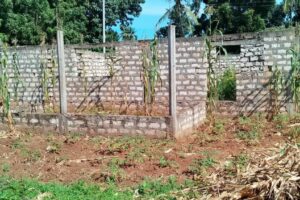
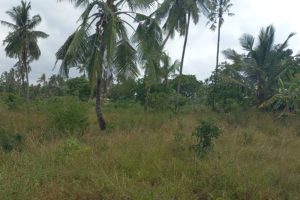
4.6 Building materials
Choice of building materials in the settlement is dependent on income. The settlement is exclusively a low-income area. Therefore, residents have chosen building materials that are within their economic means. The residents have chosen to construct semi-permanent structures as they constantly face the threat of eviction. This is because they do not have security of tenure of the land upon which they have constructed their structures.
The findings of this study indicates that most households 62 of 99 respondents choose to use iron sheets for roofing while 21 out of 99 used makuti/grass for roofing. Out of 99 households, six households did not respond to the question.
Figure 4 6: Roofing materials
Figure 4.7: Figure 4 7: Walling materials
Figure 4 8: Flooring materials
The presence of structures built with non-permanent materials such as muds for walling and makut/grass for roofing is a clear indication that the issue of housing has not been properly addressed in the area.
4.7 Number of rooms per household
Most of house structures 51.67% in the area are single units, which is a characteristic of a slum. These single units lack privacy, which is a challenge to the household. Structures with two rooms were 26.67%, those with three rooms were 15% while the mansions with five rooms were 6.67%
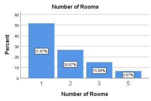
Figure 4 9: Number of rooms per structure unit
Kwa Nyambura has a mixture of temporary, semi-permanent and even permanent developments
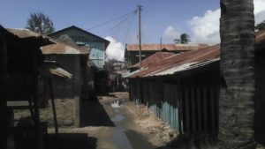
Figure 4 10: Mixed development structures
4.8 Access to Basic Services
4.8.1 Solid waste disposal
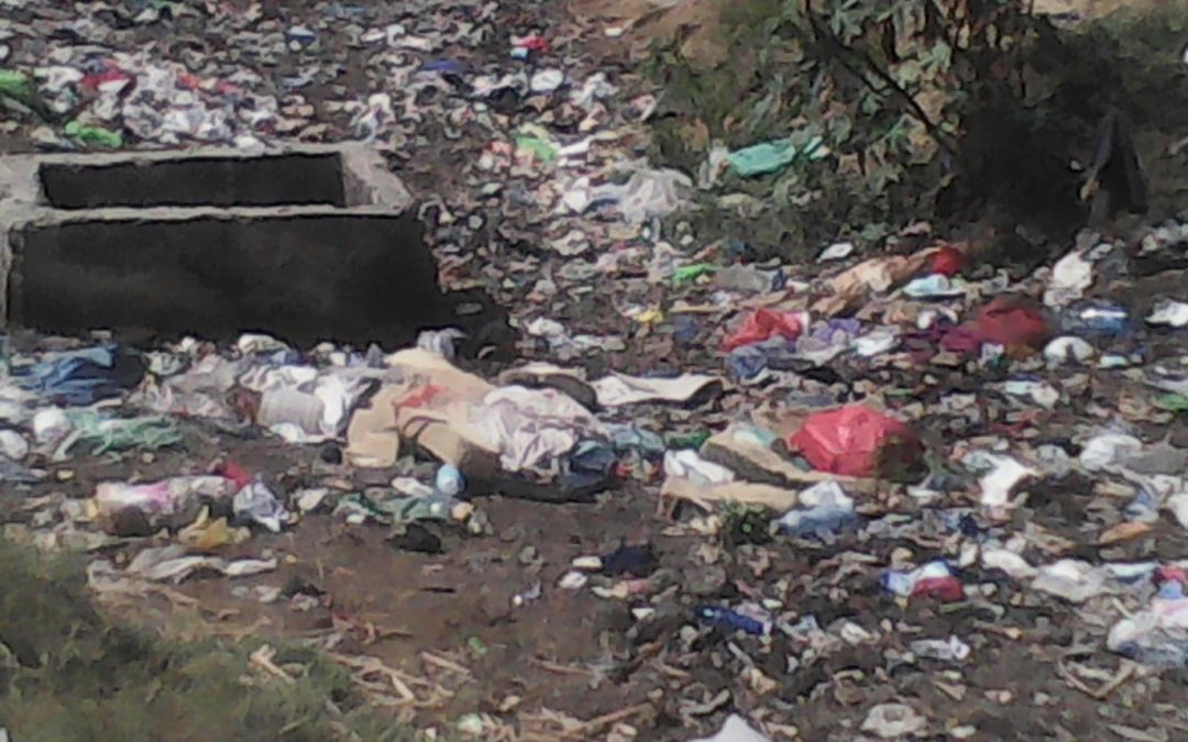
The findings of the study observation show that the residents disposed their garbage or waste into open spaces within the slums. This indicates that the Local Authorities have failed or delayed to play its role, which was to designate a public dumping site.
Therefore, the area lacks sustainable solid waste management systems to address the issue of open space dumping.
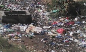
Figure 4 11: Solid waste disposal
4.8.2 Human waste disposal
The table below shows the method of human waste disposal in the area of study.
| Method of disposing Human waste |
|
Frequency |
Percent |
Valid Percent |
Cumulative Percent |
| Valid |
|
6 |
5.7 |
5.7 |
5.7 |
| pit latrine |
88 |
83.8 |
83.8 |
89.5 |
| Septic/conservancy tank |
11 |
10.5 |
10.5 |
100.0 |
| Total |
105 |
100.0 |
100.0 |
|
Table 4. 8: Human waste disposal
From the findings of this study, most of the households (83.8%) used pit latrine to dispose their human wastes while only 10.5% used septic/conservancy tank. Other options; open defecation and sewer are not applied in the area. This indicates that there is no sewerage in the area hence still a challenge of liquid waste collection.
4.8.3 Water supply
Findings of the study indicate that most of the households purchase their water from mobile water vendors who delivered the water to their doorsteps. The group discussion with some residents revealed that the area access water from boreholes which is salt hence not quality for drinking and from community two community water taps which are insufficient to supply water to large population of Kwa Nyambura.
Some residents who afford to live in mansions are supplied with pipe water. Though they complained water supply in the area is not reliable since it even take a whole week without water flowing in their taps.
The mobile water vendors complained of low pressure and large lining thus time consuming. The figure below shows mobile water vendors.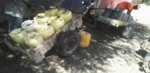
Figure 4 12: Water accessibility
4.8.4 Roads
Poor accessibility during rainy season due to poorly constructed roads that lack drainage hence flooding when it rains as shown below.
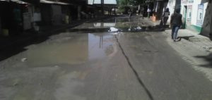
Figure 4 13: Accessibility of roads
Poor accessibility due narrowly constructed roads due to lack of enough space. This indicates that residents have constructed on the way leave. Roads are irregular in shape and very narrow.
Figure 4 14: Narrow and irregular roads
Impassable muddy roads during rainy season
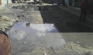
Figure 4 15: Muddy roads
4.8.5 Healthcare facilities
Mtwapa Health Centre of Excellence is the only available government health facility in the entire settlement. However, residents complained that it lacks enough medicine and they are requested to buy medicine from private chemists. The hospital operates only on weekdays and daytime. Therefore, on weekends and night hours residents are forced to visit the private health facilities, which are very expensive. The general management of this facility was poor and residents also pointed out that it did not have enough medicine.the available private health facilities include Jambo Medical Centre, Greenpark Healthcare, Madanje Medical Clinic and Kwa Georgy Medical Clinic.
Accessibility of healthcare services
|
|
Frequency |
Percent |
Valid Percent |
Cumulative Percent |
| Valid |
|
3 |
3.0 |
3.0 |
3.0 |
| Easily accessible |
18 |
18.2 |
18.2 |
21.2 |
| Accessible |
75 |
75.8 |
75.8 |
97.0 |
| Not Accessible |
3 |
3.0 |
3.0 |
100.0 |
| Total |
99 |
100.0 |
100.0 |
|
Table 4. 9: Accessibility of healthcare services
Figure 4 16: Health progress over the past few years
Figure 4 17: Jambo medical centre; private healthcare facility
Figure 4 18: Public healthcare facility
Figure 4 19: The Greenpark healthcare; private facility
4.8.6 Educational facilities
Kwa Nyambura settlement is served by two private primary schools. Mtwapa Academy School and Jambo Jipya Schools. The settlement lack a public school hence is served by private schools. Residents complained that the private schools were too expensive for the low-income earners and the nearest public school is in Mtomodoni, which is 2km away from the settlement. There is one secondary mixed day school (Jambo Jipya Schools), which is private and too expensive for the residents. 53% of the residents felt that educational facilities were adequate while the remaining 47% felt they were inadequate.
Figure 4 20 Mtwapa academy; Private facility
Figure 4 21: Jambo Jipya schools; private facility
4.8.7 Neighbourhood nature of security
Figure 4 22: Neighbourhood security
From the findings of this study 54.55% of respondents, felt that Kwa Nyambura settlement is insecure compared to 45.45% who felt the area is secure. Lack of street lighting and unemployment among youths in the area are the major identified drivers of insecurity.
CHAPTER FIVE: SUMMARY OF FINDINGS, CONCLUSIONS AND RECOMMENDATIONS.
5.0 Introduction
The main purpose of the study was to determine the challenges in upgrading urban slums by taking a case study of Kwa Nyambura slum in Mtwapa, Kilifi County, Kenya. This chapter five provides the conclusions relating the results and findings to the general literature and shows the greater context and implications. Recommendations for actions as an objective of this study (To suggest appropriate approaches for urban slum upgrading that are sustainable) are outlined too.
5.1 Summary of Finding
1st objective of the study: To determine the approach employed in upgrading Kwa Nyambura settlement and its level of success to the program.
The research findings were that a Participatory approach was employed in upgrading Mtwapa Informal Settlements hence Kwa Nyambura slum which was o. This study has proved that the uptake of slum upgrading in Kwa Nyambura village is unsuccessful due to the challenges faced in the implementation. The key issue is that the approach was not fully implemented since the target beneficiaries and various stakeholders were not actively involved in decision-making processes and in identifying the underlying causes of Kwa Nyambura slum. The stakeholders failed to incorporate appropriate intervention strategies in a holistic and inclusive slum upgrading.
The approach has unsuccessfully addressed the issue of affordable housing since the beneficiaries were responsible for the improvement of their houses and that the Council did not put up houses for the residents but linked them with NGOs’ and other possible financiers who could assist in loans. Most residents were not ready to take loans while others did not qualify to access loans due to their low incomes.
2nd objective of the study: To investigate stakeholders involved and their roles in upgrading in Kwa Nyambura informal settlement.
Stakeholders for the slum upgrading include the UN-HABITAT, Community groups, Local Authorities of Kilifi and Mombasa, Local CBOs and donors, the Ministry of Lands, local business owners and the Ministry of Local Government (MoLG).
| Stakeholder |
Role of stakeholder |
| Ministry of Lands and Settlements |
establish land tenure security by Issue of certificates of titles and Issue of lease agreements |
| Local Authorities |
1. Provide adequate fresh water for domestic and other uses through exploiting natural sources of water that is drilling of boreholes. And providing piped water.
2. designate a public dumping site |
| County Council of Kilifi and the Ministry of Roads |
open up roads of access |
| Ministry of Housing |
Rehabilitation of the informal settlement by improving housing and infrastructure. |
| Local Community |
Mobilize local resources, Cooperation and co-funding |
| CDF Committee and NGOs |
Fund of Community organizations and self-help groups to eliminate poverty |
| County Council of Kilifi |
Construct drainage systems |
| Kenya Power |
1. Installation of street lights along the roads
2. Installation of high mast security light within the settlements |
| UN – Habitat |
Fund raising, technical assistance, capacity building, good practices/experience sharing, networking |
Table 5. 1: Stakeholders and their roles
3rd objective of the study: To study slum upgrading experience in the area of study.
The low pace of upgrading process is the major challenge experienced by most stakeholders interviewed. Most development projects such as construction of drainage system, establishment sewage networks as well as septic tanks where feasible and some access roads have taken long than scheduled timeframe.
The new political regime lacks the will to support the upgrading program since it is not among its priorities.
5.2 Conclusion
In conclusion basing on the research findings, the study has successfully determined the main objective of the study; challenges experienced in upgrading urban slums by taking a case of Kwa Nyambura. The study has also been able to achieve the specific objectives as well as answering the research questions.
The results indicated that the main challenges behind the unsuccessful uptake of upgrading Kwa Nyambura slum includes:
Lack of cooperation from residents; existence of people of criminals who take advantage of informal space and property owners who make small fortunes renting out shacks to people over time. The criminals stole solar panels and destroyed streetlights whereas some landlords did not surrender their illegally owned lands despite the evidence that they had no legal documents of ownership. In addition, some residents complained that the process of acquiring documents of ownership is long, expensive, unguaranteed and time consuming.
Competing and conflicting interests within different actors; County Council of Kilifi and Ministry of Lands, Housing and Urban development have different plans for the same informal settlement (Kwa Nyambura slum).
Lack of adequate space; limits provision of public facilities and recreational areas partly due to small land sizes within the area. Even the schools in this area do not have sufficient playing grounds and access roads are very narrow. Other identified challenges include corrupt contractors, lack of political will, high rent charges from private sectors, low pace of development, and lack of ownership (tenure security) from residents.
5.3 Recommendations
- The researcher suggests that the capacity of, and efficiency among all stakeholders, including NGOs and CBOs, in the housing delivery process should be improved in order to solve the issue of competing interest among the stakeholders. This is where we find that the city council, the ministry of housing, and the ministry of lands all have different plans for the same informal settlement and therefore resulting to unclear mandate of various stakeholders.
- The researcher also recommends that government should regulate house rents according to economic class of the residents in order to enhance affordability for slum dwellers. This is because the private sector providing housing charge high rents that are beyond the capability of the slum dwellers thus attracting the middle- and high-class people leaving the issue of housing to the target beneficiaries unsolved.
- The study also recommends that the upgrading programme should liaise with the legal system to ensure that security of tenure is an integral provision for all slum dwellers to facilitate protection and sustainability. Regularization of land tenure is compulsory for any structural and infrastructural improvements to take place.
- The upgrading process should facilitate integration of participatory approach with active involvement and participation of the target beneficiaries. This will ensure that the program’s aim and objectives are well understood and accepted by the target beneficiaries hence avoid later conflicts.
- An effective slum upgrading should seek to work with contractors and NGOs that are accountable, transparent and that exhibit clear objectives. This will help to mitigate corruption.
- Time schedule should be adhered to, in order avoid interruption to other programs. This is where delay in construction of access roads will also lead to delay in provision of housing and hence informal settlements continue to deteriorate and the housing problem exacerbates.
- Both national and county governments should take a lead role to coordinate the various stakeholders involved in the upgrading programme to avoid the loss in synergy, valuable experiences and lessons.
References
Borg, W. R. & Gall, M. D. (1989). Educational Research: An Introduction. N. Y. Longman.
Bryman A. 2004. Social Research Methods. 2nd edition. Oxford University Press. New York.
Bryman, A. (2006) ‘Integrating quantitative and qualitative research: how is it done?’, Qualitative Research, vol. 6,
Creswell, J.W. (2003) Research design: Qualitative, Quantitative and Mixed Methods Approaches, 2nd edition, London: Sage.
Davis M., (2004). Planet of Slums. New Left Review 26.
Government of Kenya (2006) Kenya Slum Upgrading Programme (KENSUP). Implementation Strategy 2005 – 2020. Government Printer, Nairobi.
IFRA (2011) Slum Upgrading Programmes in Nairobi: Challenges in Implementation Contributions. IFRA’s Conference Nairobi, 6th and 7th April 2011. Nairobi, IFRA.
Kenya Republic Of (1996), Physical Planning Act, Government Printer, Nairobi
McElroy, B and Mills, c., (2000) Managing Stakeholders. Gower Publishing.
Mitullah W., (2004). The Case of Nairobi, Kenya
Mugenda, O.M. & Mugenda, A.G. (1999), Research Methods: Quantitative and Qualitative Approaches, 1st Edition, Published by ACTS Nairobi, Kenya.
Nation TV. (03-03-2009), Black Man’s land
Olima, WHO, 2001, The Dynamics and Implications of Sustaining Urban Spatial Segregation in Kenya – Experiences from Nairobi Metropolis A Paper Presented at the International Seminar on Segregation in the City Held at Lincoln Institute of Land Policy in Cambridge, MA, USA, July 25-28, 2001
Prodipto Roy and Shangon Das Gupta (1995). Urbanization and Slums, Delhi, India.
SIDA (2006) KENSUP, Capacity building assessment report and work plan, Nairobi Kenya
Tisong D. A., (2011). Slum Improvement in Ghana: the Study of Aboabo and Asawase in Kumasi. Kwame Nkrumah University of Science and Technology, Kumasi
Turner, J. (1976). Housing by People: Towards Autonomy in Building environment. London. Labyrinth Publication Ltd
Turner, J. F.C. and Geotze, Rolf (1967) Environmental Security, and Housing input.
UN-Habitat (2003b): Slums of the World
UN Habitat, 2003, The challenge of slums: global report on human settlements
UN-HABITAT (2008) UN-Habitat and the Kenya slum upgrading programme strategy document. UN.
United Nations (2010). United Nations Millennium Development Goals.
APPENDICES
Appendix I
Household questionnaire
Questionnaire Identification Information
- Questionnaire No. _______________
- Name of interviewer: ______________ _______________
- Date: ___________________
Section A: Background information
- Name of respondent (optional)………………………………………………………………………………….
- Gender of respondent a) Male b) Female
- What is your age?
| 18 – 35 years of age |
36 – 55 years of age |
Above 55 years |
|
|
|
- Marital Status a) Single b) Married c) Widowed d) Divorced
- What is your highest level of education? a) None b) Primary c) Secondary d) Tertiary
- How long have you stayed in Kwa Nyambura?
| Less than 5years |
6 to 10 years |
More than 10 years |
|
|
|
Section B: Housing
- Do you own this property? a) Own both land and structure b) Own only structure c) Not an owner
- If you own, do you have a document of ownership?
- When was this house constructed? ______________
- What are the building materials used in construction of your house?
| Roof |
Indicate type |
Walls |
Indicate type |
Floor |
Indicate type |
| Iron sheets |
|
Cement blocks |
|
Cement |
|
| Tiles |
|
Bricks |
|
Tiles |
|
| Makuti/grass |
|
Mud and poles |
|
Mud |
|
| Concreate |
|
Timber |
|
Wooden |
|
| Any other(specify) |
|
Any other(specify) |
|
Any other(specify) |
|
- How many rooms does your current house have? ___________
- Do you rent out other rooms in your structure?
……………………………………………………………………………………………… ……………………………………………………………………………………………… ………………………………………………………………………………………………
- If you are a tenant, how much rent do you pay per month?
| Below Ksh. 2000 |
Ksh. 2000 to 5000 |
Above Ksh. 5000 |
|
|
|
- How do you dispose solid wastes from your household?
| Burn |
|
| Bury |
|
| Gabbage collectors |
|
| Any other(specify) |
|
- How do you dispose Human wastes in your household?
| Pit latrine |
|
| Septic/conservancy tank |
|
| Sewer |
|
| Bush |
|
| Any other(specify) |
|
- What is the nature of your neighbourhood security? a) Secure b) Insecure
- . If secure, what has contributed to the neighbourhood being secure? ………………………………………………………………………………………………………………………………………………………………………………………………………………………………………………………………………………………………………………………………………………………………………………………………………………
- If not secure, what are the causes of insecurity? ………………………………………………………………………………………………………………………………………………………………………………………………………………………………………………………………………………………………………………………………………………………………………………………………………………
Section C: Education Related
- Are your children in private or public school? a) Public b) Private
- How much do you pay per child in a year?
| Nursery |
|
| Primary |
|
| Secondary |
|
| Tertiary |
|
- What challenges do you face in accessing educational facilities and services in this area?
Section D: Health Care Related
- Accessibility of health care services a) Easily accessible b) Accessible c) Not Accessible
- Where do members of your households seek health services from? a) Private b) Public
- Why do you prefer? a) Trust factor b) Financial reasons c) Better quality services d)Any other (specify) ____________________
- What are the recurrent diseases for which you spend?
……………………………………………………………………………………………………………………………………………………………………………………………………………………………………………………………………………………………………….
- What is your opinion on the quality of health care being provided in this area over the past few years? a) Has Improved b) No Change c) Has deteriorated
- . Rate the nature of healthcare provided in this area? a) Excellent b) Very Good c) Good d) Fair e) Poor
Section E: Challenges facing Infrastructure Provision in the Slums
- i) Within the period you have stayed in this area have there been any projects that have targeted infrastructure improvement and upgrading in this area? a) Yes b) No
- ii) If yes, which ones? ……………………………………………………………………………………………. ………………………………………………………………………………………………………………………………………………………………………………………………………………………………………………………………………………………………………………………………………………………………………………………………
- How has been the implementation of slum upgrading in Kwa Nyambura settlement?
………………………………………………………………………………………………………………………………………………………………………………………………………………………………………………………………………………………………………………………………………………………………………………………………
- How has the upgrading project affected your living conditions? ……………………………………………………………………………………………… ……………………………………………………………………………………………… ……………………………………………………………………………………………… ……………………………………………………………………………………………….
- From your own point of view, which challenges do you think face the provision of the following services and facilities?
- a)Water ………………………………………………………………………………………………………………………… ………………………………………………………………………………………………………………………………………………………………………………………………………………………………………………………………………………………………………………………………………………………………………………
- b) Health Services ………………………………………………………………………………………………………………………………………………………………………………………………………………………………………………………………………………………………………………………………………………………………………………………………………………………………………………………………………………………………………………………………
- c) Electricity ………………………………………………………………………………………………………………………………………………………………………………………………………………………………………………………………………………………………………………………………………………………………………………………………………………………………………………………………………………………………………………………………
- d) Sewerage ………………………………………………………………………………………………………………………………………………………………………………………………………………………………………………………………………………………………………………………………………………………………………………………………
- e) Roads
……………………………………………………………………………………………………………………………………………………………………………………………………………………………………………………………………………………………………………………………………………………………………………………………………………………………………………………………………………………………………………………………………………………………………………………………
f) Recreation ………………………………………………………………………………………………………………………………………………………………………………………………………………………………………………………………
Thank you.
Appendix II
Interview Schedule for Department of Physical Planning; Kilifi County.
- Name of respondent………………………………………………………………………………………..
- Date of interview……………………………………………………………………………………………
- Title/position…………………………………………………………………………………………………
- Organization………………………………………………………………………………………………….
- Department……………………………………………………………………………………………………
- Which policy initiatives have been initiated by the government to address challenges of slums upgrading?_______________________________________________________________________________________________________________________________________________________________________________________________________________________________________________________________________________________________________________________________________________________________
- a). at which level of development process did you (your organization) participate in the Mtwapa Informal Settlements Upgrading Programme?
________________________________________________________________________________________________________________________________________________________________________________________________________________________
b). what role has your organization/department played as a stakeholder in Mtwapa Informal Settlements Upgrading Programme more particularly at Kwa Nyambura area?
________________________________________________________________________________________________________________________________________________________________________________________________________________________
c). what are the challenges you encountered during the process?
________________________________________________________________________________________________________________________________________________________________________________________________________________________________________________________________________________________________
- a). who are the other main stakeholders in the Upgrading Programme?
b). at which level of development process were they involved?
________________________________________________________________________________________________________________________________________________________________________________________________________________________________________________________________________________________________
c). what are the roles of each stakeholder in the programme?
________________________________________________________________________________________________________________________________________________________________________________________________________________________________________________________________________________________________
- a). What approach of upgrading urban slums/informal settlements was employed in upgrading Mtwapa Informal Settlements?
________________________________________________________________________________________________________________________________________________________________________________________________________________________________________________________________________________________________
b). why was the approach preferred?
________________________________________________________________________________________________________________________________________________________________________________________________________________________________________________________________________________________________
c). to what extent has the approach contributed to ensure that upgrading of Mtwapa Informal Settlements is successfully implemented?
________________________________________________________________________________________________________________________________________________________________________________________________________________________________________________________________________________________________
- What institutional arrangements have been put in place for upgrading Mtwapa Informal Settlements?
________________________________________________________________________________________________________________________________________________________________________________________________________________________________________________________________________________________________
- Have you successfully implemented any housing project in Kwa Nyambura settlement or any of Mtwapa informal settlements? If yes, what challenges did you encounter and how did you overcome them?
________________________________________________________________________________________________________________________________________________________________________________________________________________________________________________________________________________________________
- What lessons did you learn from those experiences and how do you think they can help improve housing in any other urban slum or informal settlement?
________________________________________________________________________________________________________________________________________________________________________________________________________________________________________________________________________________________________
Thank you.
Appendix III
Focus group discussions with residents and the elder of Kwa Nyambura Slum
- Discuss the land tenure of this settlement
- In case you secured this land, how would you improve your houses and in what stages?
- Within the period you have stayed in this area, have there been any projects that have targeted infrastructure improvement and upgrading in this area? a) Yes b) No
- If yes, which ones?
- What do you think the county government can do to address challenges associated with the following
| Challenge |
Solution |
| Water |
|
| Health Services |
|
| Electricity |
|
| Sewerage |
|
| Roads |
|
| Recreation |
|
| Education |
|
- Do you feel that the government has done enough in addressing the plight of slum dwellers especially in provision of low-cost housing units? Why do you think this is so?
- What would you want the government to do in order to improve your housing conditions?
Appendix IV
Checklist
| NO: |
Facility/Service |
Availability (YES or NO) |
Status (quality and effectiveness) |
Intervention |
| 1 |
Sewerage |
|
|
|
| 2 |
Sanitation |
|
|
|
| 3 |
Roads |
|
|
|
| 4 |
Healthcare facilities |
|
|
|
| 5 |
Schools |
|
|
|
| 6 |
Water |
|
|
|
| 7 |
Drainage |
|
|
|
| 8 |
Space |
|
|
|
| 9 |
Way leave |
|
|
|
| 10 |
Semi permanents |
|
|
|
| 11 |
Street lights |
|
|
|
| 12 |
Recreational facilities |
|
|
|
Georole Ltd,
Land surveying | Valuation & Advisory | Property & Estate Agency | Physical & Land Use Planning | Environmental Management | Architecture & Landscaping
Contact: 0113209028
Email: georole20@gmail.com | info@georole.co.ke
 Satellite image showing property location