by Georole Ltd | May 17, 2023 | environnment management
sustainable water solution?
Sustainable solutions can be defined as balanced approaches that preserve the long term well-being of communities and the environment by investing in and promoting economically sound, socially desirable and environmentally healthy projects, programs, and services to achieve multiple benefits.
Introduction
Many counties in Kenya, have been grappling with the devastating effects of drought. The scarcity of water has had severe repercussions on herders, farmers, and the general population, causing loss of livelihoods and immense suffering. While the counties’ budgetary allocation focuses on the construction of water pans, questions arise when rainfall fails to replenish these water sources. Who should be held accountable for this predicament? And who truly benefits from these projects—the people of citizens or the so-called ‘tenderpreneurs’ who may be profiting from kickbacks and questionable construction practices?
Addressing the water pan dilemma
It is disheartening to witness the financial investment in water pan construction fail to alleviate the water crisis in most counties. However, despite the challenges, it is essential to explore alternative approaches that can provide sustainable water solution. One such approach is the utilization of available technology to purify and make use of even brackish or salty water sources. By investing in water purification technologies, the counties can ensure that their residents have access to clean water, regardless of its source.
Unveiling of the water pan economics
Let’s delve into the economics behind water pan construction. A medium-sized water pan can cost up to 3 million Kenyan shillings. However, a closer examination reveals that the actual expenses incurred during construction may not justify the substantial budget allocation. For instance, the machinery used for digging can cost 8,000 shillings per hour, amounting to 64,000 shillings for an 8-hour workday. When we factor in other expenses such as fuel and personnel payments, the total budget may reach around 100,000 shillings per day. Assuming the work is completed within 10 days, the total expenditure amounts to approximately 1 million shillings. Consequently, a significant profit margin of 2 million shillings remains unaccounted for.
The role of sustainable water management
The inherent challenge with water pans lies in their reliance on rainfall, which has become increasingly unpredictable due to global climatic changes. To ensure the provision of clean water residents, it is crucial for county government to adopt alternative strategies for sustainable water management. Exploring innovative water solutions such as rainwater harvesting, conservation practices, and the promotion of efficient water use can mitigate the effects of water scarcity and enhance the resilience of communities.
Way forward
The county governments must take a human rights-based approach (HRBA) to find water solution. They are duty-bearers of providing water and sanitation services to people, who are rights-holders. Rights-holders can claim their rights and duty-bearers must guarantee the rights to water and sanitation equally and without discrimination.
Conclusion
The water pan construction challenge exposes the need for a more sustainable water solution and people-centered approach to water management. By critically examining the economics behind water pan construction and acknowledging the changing climate, can pave the way for lasting water solutions. It is better to move beyond short-term fixes and embrace innovative strategies that ensure access to clean water for the people, thus transforming their lives and fostering a brighter and more resilient future.

Access to water and sanitation are recognized by the United Nations as human rights – fundamental to everyone’s health, dignity and prosperity. The right to water entitles everyone to have access to sufficient, safe, acceptable, physically accessible, and affordable water for personal and domestic use.
In our subsequent posts, we will share our perspective on potential strategies to acquire a sustainable water solution that will address Counties water challenges. These proposals aim to empower the county’s residents with access to clean and sustainable water sources, mitigating their dependence on unreliable rainfall patterns. It is time to come together as a community, transcend political boundaries, and advocate for long-term solutions that prioritize the well-being of the people over profit-driven motives.
Georole Ltd,
Land surveying | Valuation & Advisory | Property & Estate Agency | Physical & Land Use Planning | Environmental Management | Architecture & Landscaping
Contact: 0113209028
Email: georole20@gmail.com | info@georole.co.ke

by Georole Ltd | May 16, 2023 | Valuation
In Kenya, there are currently about 6 major niches of real estate within which one can invest. These include:
Niche #1: land/property brokerage
A fee is charged by the mediator who facilitates a real estate transaction between the two parties.
Niche #2: land development
This is a business where one buy land and improve it by adding services and utilities such like roads, electricity, and water. He/she then divides the land into smaller planned plots and sell them out for a profit.
Niche #3: condominium development
This entails constructing a Building , dividing it into different units, and selling out the units.
Niche #4: commercial development
This is a kind of business where one construct a building and Let out each of the units at a monthly fee.
Niche #5: estate management
It is a business where one manages a property owned by someone else.
Niche #6: real estate appraisal
This requires one to be an expert specilised in land economics or real estate as well as registered and licensed by the the valuers registration board (VRB) to offer valuation services.
Recommendations
You can set up business within the 6 niches or specialize in a specific Niche
How to start a small real estates business Kenya.
- If you have very little spending money to capitalize in real estate business, begin by helping your neighbor or friends sell thier properties for a commission. As you grow, you will be able to register a formal agency and handle bigger business.
- One can as well buy land from an individual slice it into smaller plots and sell the small plots to your clients at a profit.
- Purchase many plots, say five, from a Land Real Estate Developer and when their value increases, within 6 months to 2 years, you then re-sell these same plots at a profit.
- Buy the plots, construct your own small residential units and rent them out.
- Buy several units within a condominium and then rent them out for a monthly income.
- Get a lease for a huge chunk of land, sub-lease the biggest portion of it for some monthly income while you develop a small manageable potion of this land.
- Buy a piece of land in a prime area, construct a nice home, and rent out this home for a monthly income.
- If you have a little more money, you can buy an old house, within a prime area, give it a face lift, and sell your new house for a profit.
“If you found this article helpful, consider supporting our work to keep creating valuable content.”
Presented by:
Georole Ltd,
Land surveying | Valuation & Advisory | Property & Estate Agency | Physical & Land Use Planning | Environmental Management | Architecture & Landscaping
Contact: 0113209028
Email: georole20@gmail.com | info@georole.co.ke
by Georole Ltd | May 16, 2023 | Valuation
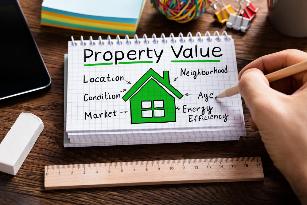
why is land valuation important?
Property Valuation is important when buying a land and its transfer. An application for valuation is always made to the government valuer, or to a registered Valuation firm which makes a site visit to enable them to prepare the requisite valuation report all for purposes of Stamp Duty. This duty is vital since it acts as a registration fee for the property. The duty is determined by a professional government valuer and the valuation is to determine the true open market value of the property as at the date of transfer.

The buyer has the responsibility of applying for property valuation of the land using the valuation form properly completed by the seller. The lands office uses such papers to fix the stamp duty payable.
Final payment and transfer of ownership
On receiving the completion documents from the seller, the buyer is obliged to pay to the seller the total balance on the purchase price to complete the registration of the documents following payment of the obligatory stamp duty. Documents from the lawyers of the seller encompass the land’s original title deed, the signed and witnessed transfer documents into the buyer’s names, receipts indication paid-up land rents plus clearance certificate, and the consent to transfer.
In case you find the article useful and would like to support me, you can buy me a coffee ☕
Presented by:
Georole Ltd,
Land surveying | Valuation & Advisory | Property & Estate Agency | Physical & Land Use Planning | Environmental Management | Architecture & Landscaping
Contact: 0113209028
Email: georole20@gmail.com | info@georole.co.ke

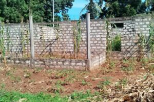
by Georole Ltd | May 16, 2023 | land survey, Valuation
Property boundary is an imaginary line at the ground surface, and its vertical extension that separates the real property owned by one person from that property owned by another person.
How to determine the actual location of your property boundary?
Land titles give an indication of boundary dimensions by making reference to a diagram i.e. map. However, only a licensed surveyor can determine the actual location of your property boundaries. If you are buying property, you need to know and be sure of what you are getting. This is possible through engaging a licensed surveyor to rightly define the property boundary of what you are about to purchase, otherwise brokers and the land owner can trick you into paying more for less.
The surveyor gives you a form of protection in addition to clarifying what you have bought, since it will reveal any encroachments or other irregularities. The surveyor will mark the exact corners of your site with survey monuments.
Fencing your property by erecting fences around your property gives you many benefits. You can decide how your area will look, once you have the boundary. Some of the benefits include:
Increase the degree of protection.
It acts as a deterrent to outside people who may wish to intrude on your home. You can also keep away thieves and burglars with the use of these fences..
Insuring your property
Due to added protection, there is increased chances of one to get lower premium quotes for his/her homeowner’s insurance. This lower financial risk just in case anything negative occur. With discounts from your premiums, you are able to gain more savings and spend it on other needs.
Value addition
When it comes to financial gain, adding up fences around your property increases the latter’s value. If you intend to sell your property, you will get it appraised by authorities. Authorities give more weight to properties that are well protected. This is why you can enjoy a higher price for your property.

Delineate property lines
In legal sense, a fence can delineate your property boundary properly. This will somehow reduce the possibilities of fights and quarrels with neighbours since you and they know where your area of responsibility stops thus, fences can actually contribute to the peace and order that each community is experiencing.
Promotion of psychological safety and security.
If the latter two are your primary reasons for building a fence, then it is only reasonable to deduce that the fence is going to be of considerable height. It can block the vision of people from the outside towards the inside of your home. Thus, better privacy can be enjoyed too.
conclution and recommendations
Many people face challenges to identify property boundary (ies) when buying land. This has become very critical in these times where land grabbing and trespass are common. People are conscious of boundaries in the fear of encroachers on their land. This is a natural instinct people are born with. If animals can mark their territories in various ways, why not humans?
The physical property boundary may be a fence, wall or a hedge, mark stones among others. It follows the line of the legal boundary.an architect is usually the best person to consult on the kind of boundary you would like to put up. “The options and configurations are unlimited. The decision to have live fence or wall, hedge or chain link can be well articulated by an architect
Every piece of land, whether registered or not, has legal boundaries. The legal boundary is an imaginary or invisible
line that divides one person’s property from another. In the urban setting, boundary walls are very popular and are in various designs. They give a sense of security. They can be built from burnt bricks, cement blocks, stone or concrete. The finishes also range from plasters, claddings and stone pitching. Some developers grow creepers on the walls to tone down its boring appearance.
In case you find the article useful and would like to support me, you can buy me a coffee ☕
Georole Ltd,
Land surveying | Valuation & Advisory | Property & Estate Agency | Physical & Land Use Planning | Environmental Management | Architecture & Landscaping
Contact: 0113209028
Email: georole20@gmail.com | info@georole.co.ke
by Georole Ltd | May 13, 2023 | land survey
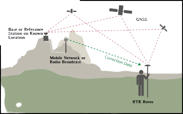
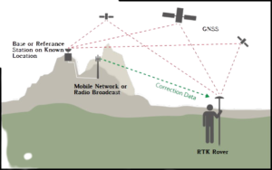
What is Real-time kinematic?
Real-time kinematic, also known as RTK, is a surveying technology which measures the relative positions while using two different Global Navigation Satellite System (GNSS) antennas in real-time with better accuracy. The errors found in GNSS results are decided and fixed using RTK technology. The new generation of intelligent RTK systems provide reception of all available satellite signals. Because of this, slope measurement can be taken without centering and calibration increases productivity by 20%. With this high tech technology, it ensures continuation of a RTK survey incase of temporary interruption of correction signal reception.
Components and Working of Real-Time Kinematic (RTK) Survey
An RTK setup consists of two receivers. One of them, called the base station or GNNS receiver, is stationary, while the second receiver called rover moves freely.
The base station is a static point whose coordinates are fixed and determined by other precision methods in surveying. It uses GNSS to compute errors in this point by comparing it to its precise location. The error determined is transmitted in real-time to the rover. The objective of the antenna at the base station is to remain at one point and send the corrections to the moving receiver.
Rover uses these corrections to improve its computed position from the GNSS and achieve centimeter-level precision. More than one rover is used and can be connected to one base if their input settings match with the output from the base.
Traditional GNSS receivers measure the time taken for a signal to travel from a satellite to the receiver. These receivers determine the position with 2-4 meter accuracy. But the incorporation of RTK gives the relative position in centimeter accuracy.
RTK is mainly used for construction applications that require higher frequency like cadastral survey, drone navigation, and other construction activities.
Benefits of RTK
- RTK technology provides centimeter-level accuracy and eliminates human errors caused in traditional surveying.
- RTK systems rely on satellite, radio positioning and communication, thereby helping conduct surveying faster than traditional methods.
- RTK survey helps to develop construction layouts quickly.
RTK is mainly used for construction applications that require higher frequency like cadastral survey, drone navigation, and other construction activities. This technology is unavailable in marine areas, lands with obstructions such as trees, mountains, etc. , or projects that could disrupt communication. The RTK system requires a pre-surveyed base station with known coordinates beforehand.
In case you find the article useful and would like to support me, you can buy me a coffee ☕