by samson | Mar 29, 2025 | land survey
Steps to registering community land
Step 1: Community Registration
- Hold public meetings to pass a resolution.
- Submit Form CLA 3 (Application for Registration) signed by 15+ members.
Step 2: Public Meeting Notice
- The Registrar publishes notices in newspapers, radio, and local offices.
Step 3: Elect the CLMC
- Members (7–15) are elected via secret ballot. Submit Form CLA 2 for committee changes.
Step 4: Land Registration
- CLMC submits Form CLA 1 (Claim Application) with maps and governance documents.
- Receive Form CLA 4 (Certificate of Registration) upon approval.
Download Form CLA 1, Form CLA 2, Form CLA 3, Form CLA 4 and Form CLA 8.
Free Download: GEOROLE’S FREE CHECKLIST FOR COMMUNITY LAND REGISTRATION IN KENYA
Get our step-by-step guide to avoid missed deadlines and bureaucratic traps

by Georole Ltd | Mar 29, 2025 | land survey, physical and land use planning
The Community Land Act 2016 enforces strict inclusivity and penalties for non-compliance:
- Gender Equity: At least 1/3 of CLMC members must be women.
- Penalties: Fines up to KES 500,000 or 3-year imprisonment for violations.
- Non-Discrimination: Communities excluding minorities or women risk registration denial.
- Equal Rights: Customary land rights hold equal legal weight as freehold titles.
These provisions protect marginalized groups and uphold constitutional values.
What next? Step-by-Step Guide to Registering Land under community in Kenya. Read Now

by Georole Ltd | Mar 29, 2025 | land survey, physical and land use planning
Understanding the jargon in Kenya’s Community Land Act 2016 is critical for successful registration. Here’s a breakdown of essential terms:
- Community: An organized group sharing ancestry, culture, livelihood, or geographical space.
- Community Assembly: A gathering of registered adults to discuss land matters.
- CLMC: The elected Community Land Management Committee overseeing land registration and governance.
- Adjudication Team: Surveyors, planners, and officers tasked with demarcating boundaries.
- Registrar: The official responsible for processing land registration applications.
These definitions ensure clarity and compliance with legal requirements.
Discover legal safeguards and inclusivity in Kenya’s land registration process for community. Don’t miss out on actionable insights! 🌍 Read the Next Article
by samson | May 17, 2023 | land survey
Where should I find RTK correction services? worry no more. Here we are linking you to solution.
Muya CORS provides Real-Time Kinematic (RTK) corrections and Post-Processing (PP) services utilizing a network of Continuously Operating Global Navigation Satellite Systems(GNSS) Reference Stations (CORSs). Our CORS tracks all available GNSS satellites including GPS, GLONASS, BEIDOU and Galileo. It also provides static data RINEX files thereby increasing redundancy in static observations and precision of positioning. The solutions of our CORS are based on the most current ITRF realization(ITRF2014). The CORS are also fixed with respect to Kenya datum.
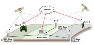
We are providing GNSS base stations and therefore no need for RTK GNSS base station. This saves users on GNSS base receiver costs and time usually taken in setting it up! Users only require a GNSS Rover and register with us. On registration, users automatically receive individual logging details to receive RTK corrections including IPs, Port, user name and password.
On registration users simply Connect, Correct, and Measure 24/7.
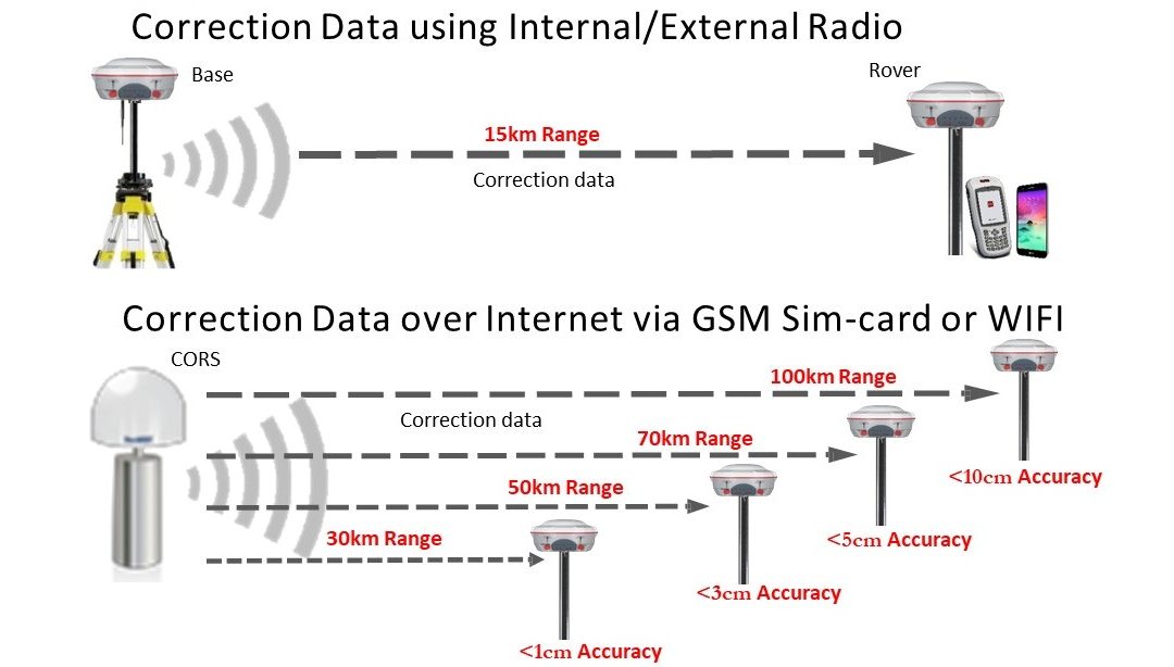
RTK corrections are available
- Single CORS RTK corrections: from the nearest CORS to the User including Nearest RTCM 3.2, 3.1 and 2.3
- Networked CORS RTK corrections: averaged corrections from at least 3 nearest CORS including VRS 3.2, 3.1 and 2.3
Expected positioning accuracies
- 1cm accuracy within 30km from the CORS
- 5cm accuracy within 50km from the CORS
- 10cm accuracy within 100km from the CORS
- 50cm accuracy within 400km from the CORS
- 1cm accuracy within VRS covered areas
GNSS training
Muya CORS also offers GNSS Training packages designed for existing surveyors and engineers. A basic understanding of survey or setting out practices is required. If you are interested in taking part in a training course please contact us with your requirements and a member of the training team will be in contact to discuss your requirements.
When it comes to customer training and development, they’re working hard to bring something different to the table. In addition to technical support, they also understand that high quality training is critical and key to unlocking the full potential of your GNSS survey equipment. Their structured training programmes will enable you to take full advantage of your instrument’s capabilities, and improve your workflow both in the field and the office, with a view to increasing your productivity and streamlining your project workflows.


They offer a flexible selection of training packages to suit your company’s needs,experience and time frame, as well as the option to create your own based around the specific requirements of your project or organization.
GNSS RTK configuration & practice
This course is designed to introduce individuals to the theory and practice of using RTK GNSS for centimeter-level positioning.
Upon completion of the course the participants will be able to:
- Understand overview of GNSS Technologies
- Identify the errors associated with GNSS and mitigation measures
- Continuously Observation Reference Stations(CORS)
- Understand the coordinates systems
- Concept of RTK
- Configuration practice on RTK Base/Rover, CORS/Rover using Microsurvey Fieldgenius and Android based GNSS field software
- Practice field works on RTK using Base/Rover, CORS/RTK using Microsurvey Fieldgenius and Android based GNSS field software
GNSS data processing
This course is suitable for those who have survey experience on carrying their static GNSS observations and require to gain practical skills on GNSS data processing.
Upon completion of the course the participants will be able to:
- Understand overview of GNSS Technologies
- Understand coordinate systems
- Identify various GNSS data processing software
- Identify various GNSS data and data formats and conversions
- Identify and use GNSS data from available CORS networks
- Understand the general flow/process of GNSS data processing
- Practice using selected software(Users may request)
GNSS CORS training
Theory: 1. Basic RTK concept, 2. Components of CORS, 3. Surveying with CORS, 4. Advantages of using CORS, 5. RTK Services in Kenya.
Practical: 1. Register with CORS service provider, 2. Subscribe RTK corrections, 3. Rover configuration, 4. Surveying with CORS
Georole Ltd,
Land surveying | Valuation & Advisory | Property & Estate Agency | Physical & Land Use Planning | Environmental Management | Architecture & Landscaping
Contact: 0113209028
Email: georole20@gmail.com | info@georole.co.ke
by samson | May 16, 2023 | land survey, physical and land use planning
A land policy can be defined as a set of rules and guidelines that govern how a country’s administration will govern, manage and administer land in that country.
The principles of land policy
Land in Kenya shall be held, used and managed in a manner that is equitable, efficient, productive and sustainable, and in accordance with the following Principles
- equitable access to land;

- security of land rights;
- sustainable and productive management of land resources;
- transparent and cost-effective administration of land;
- sound conservation and protection of ecologically sensitive areas;
- elimination of gender discrimination in law, customs and practices related to land and property in land; and
- encouragement of communities to settle land disputes through recognised local community initiatives consistent with this Constitution.
These principles shall be implemented through a national land policy developed and reviewed regularly by the national government and through legislation.
Georole Ltd,
Land surveying | Valuation & Advisory | Property & Estate Agency | Physical & Land Use Planning | Environmental Management | Architecture & Landscaping
Contact: 0113209028
Email: georole20@gmail.com | info@georole.co.ke
by Georole Ltd | May 16, 2023 | land survey, Valuation
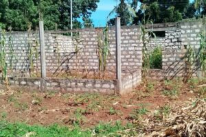
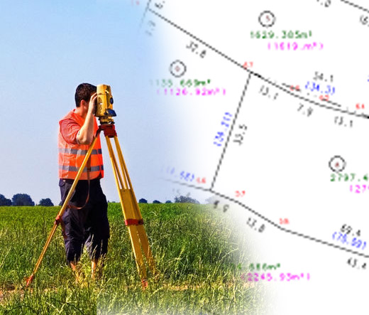
Property boundary is an imaginary line at the ground surface, and its vertical extension that separates the real property owned by one person from that property owned by another person.
How to determine the actual location of your property boundary?
Land titles give an indication of boundary dimensions by making reference to a diagram i.e. map. However, only a licensed surveyor can determine the actual location of your property boundaries. If you are buying property, you need to know and be sure of what you are getting. This is possible through engaging a licensed surveyor to rightly define the property boundary of what you are about to purchase, otherwise brokers and the land owner can trick you into paying more for less.
The surveyor gives you a form of protection in addition to clarifying what you have bought, since it will reveal any encroachments or other irregularities. The surveyor will mark the exact corners of your site with survey monuments.
Fencing your property by erecting fences around your property gives you many benefits. You can decide how your area will look, once you have the boundary. Some of the benefits include:
Increase the degree of protection.
It acts as a deterrent to outside people who may wish to intrude on your home. You can also keep away thieves and burglars with the use of these fences..
Insuring your property
Due to added protection, there is increased chances of one to get lower premium quotes for his/her homeowner’s insurance. This lower financial risk just in case anything negative occur. With discounts from your premiums, you are able to gain more savings and spend it on other needs.
Value addition
When it comes to financial gain, adding up fences around your property increases the latter’s value. If you intend to sell your property, you will get it appraised by authorities. Authorities give more weight to properties that are well protected. This is why you can enjoy a higher price for your property.

Delineate property lines
In legal sense, a fence can delineate your property boundary properly. This will somehow reduce the possibilities of fights and quarrels with neighbours since you and they know where your area of responsibility stops thus, fences can actually contribute to the peace and order that each community is experiencing.
Promotion of psychological safety and security.
If the latter two are your primary reasons for building a fence, then it is only reasonable to deduce that the fence is going to be of considerable height. It can block the vision of people from the outside towards the inside of your home. Thus, better privacy can be enjoyed too.
conclution and recommendations
Many people face challenges to identify property boundary (ies) when buying land. This has become very critical in these times where land grabbing and trespass are common. People are conscious of boundaries in the fear of encroachers on their land. This is a natural instinct people are born with. If animals can mark their territories in various ways, why not humans?
The physical property boundary may be a fence, wall or a hedge, mark stones among others. It follows the line of the legal boundary.an architect is usually the best person to consult on the kind of boundary you would like to put up. “The options and configurations are unlimited. The decision to have live fence or wall, hedge or chain link can be well articulated by an architect
Every piece of land, whether registered or not, has legal boundaries. The legal boundary is an imaginary or invisible
line that divides one person’s property from another. In the urban setting, boundary walls are very popular and are in various designs. They give a sense of security. They can be built from burnt bricks, cement blocks, stone or concrete. The finishes also range from plasters, claddings and stone pitching. Some developers grow creepers on the walls to tone down its boring appearance.
In case you find the article useful and would like to support me, you can buy me a coffee ☕
Georole Ltd,
Land surveying | Valuation & Advisory | Property & Estate Agency | Physical & Land Use Planning | Environmental Management | Architecture & Landscaping
Contact: 0113209028
Email: georole20@gmail.com | info@georole.co.ke