
by samson | May 14, 2023 | land survey, physical and land use planning
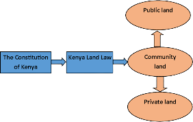
classification of land:All land in Kenya belongs to the people of Kenya collectively as a nation, as communities and as individuals. Land in Kenya is classified as public, community or private.
Public Land
- Public land is;
- land which at the effective date was unalienated government land as defined by an Act of Parliament in force at the effective date;
- land lawfully held, used or occupied by any State organ, except any such land that is occupied by the State organ as lessee under a private lease;
- land transferred to the State by way of sale, reversion or surrender;
- land in respect of which no individual or community ownership can be established by any legal process;
- land in respect of which no heir can be identified by any legal process;
- all minerals and mineral oils as defined by law;
- government forests other than forests to which Article 63 (2) (d) (i) applies, government game reserves, water catchment areas, national parks, government animal sanctuaries, and specially protected areas;
- all roads and thoroughfares provided for by an Act of Parliament;
- all rivers, lakes and other water bodies as defined by an Act of Parliament;
- the territorial sea, the exclusive economic zone and the sea bed;
- the continental shelf;
- all land between the high and low water marks;
- any land not classified as private or community land under this Constitution; and
- any other land declared to be public land by an Act of Parliament i). in force at the effective date; or ii). enacted after the effective date.
- Public land shall vest in and be held by a county government in trust for the people resident in the county, and shall be administered on their behalf by the National Land Commission, if it is classified under
- clause (1) (a), (c), (d) or (e); and
- clause (1) (b), other than land held, used or occupied by a national State organ.
- Public land classified under clause (1) (f) to (m) shall vest in and be held by the national government in trust for the people of Kenya and shall be administered on their behalf by the National Land Commission.
- Public land shall not be disposed of or otherwise used except in terms of an Act of Parliament specifying the nature and terms of that disposal or use.
Community Land
- Community land shall vest in and be held by communities identified on the basis of ethnicity, culture or similar community of interest.
- Community land consists of –
- land lawfully registered in the name of group representatives under the provisions of any law;
- land lawfully transferred to a specific community by any process of law;
- any other land declared to be community land by an Act of Parliament; and
- land that is: 1. lawfully held, managed or used by specific communities as community forests, grazing areas or shrines; 2. ancestral lands and lands traditionally occupied by hunter-gatherer communities; or 3. lawfully held as trust land by the county governments, but not including any public land held in trust by the county government under Article 62 (2).
- Any unregistered community land shall be held in trust by county governments on behalf of the communities for which it is held.
- Community land shall not be disposed of or otherwise used except in terms of legislation specifying the nature and extent of the rights of members of each community individually and collectively.
- Parliament shall enact legislation to give effect to this Article.
Private Land
Private land consists of –
- registered land held by any person under any freehold tenure;
- land held by any person under leasehold tenure; and
- any other land declared private land under an Act of Parliament.
Don’t hesitate to contact Georole for advice and whenever you need to know all about land ownership and classification.
In case you find the article useful and would like to support me, you can buy me a coffee ☕
by Georole Ltd | May 13, 2023 | land survey
What is Real-time kinematic?
Real-time kinematic, also known as RTK, is a surveying technology which measures the relative positions while using two different Global Navigation Satellite System (GNSS) antennas in real-time with better accuracy. The errors found in GNSS results are decided and fixed using RTK technology. The new generation of intelligent RTK systems provide reception of all available satellite signals. Because of this, slope measurement can be taken without centering and calibration increases productivity by 20%. With this high tech technology, it ensures continuation of a RTK survey incase of temporary interruption of correction signal reception.
Components and Working of Real-Time Kinematic (RTK) Survey
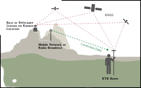
An RTK setup consists of two receivers. One of them, called the base station or GNNS receiver, is stationary, while the second receiver called rover moves freely.
The base station is a static point whose coordinates are fixed and determined by other precision methods in surveying. It uses GNSS to compute errors in this point by comparing it to its precise location. The error determined is transmitted in real-time to the rover. The objective of the antenna at the base station is to remain at one point and send the corrections to the moving receiver.
Rover uses these corrections to improve its computed position from the GNSS and achieve centimeter-level precision. More than one rover is used and can be connected to one base if their input settings match with the output from the base.
Traditional GNSS receivers measure the time taken for a signal to travel from a satellite to the receiver. These receivers determine the position with 2-4 meter accuracy. But the incorporation of RTK gives the relative position in centimeter accuracy.
RTK is mainly used for construction applications that require higher frequency like cadastral survey, drone navigation, and other construction activities.
Benefits of RTK
- RTK technology provides centimeter-level accuracy and eliminates human errors caused in traditional surveying.
- RTK systems rely on satellite, radio positioning and communication, thereby helping conduct surveying faster than traditional methods.
- RTK survey helps to develop construction layouts quickly.
RTK is mainly used for construction applications that require higher frequency like cadastral survey, drone navigation, and other construction activities. This technology is unavailable in marine areas, lands with obstructions such as trees, mountains, etc. , or projects that could disrupt communication. The RTK system requires a pre-surveyed base station with known coordinates beforehand.
In case you find the article useful and would like to support me, you can buy me a coffee ☕

by Georole Ltd | May 13, 2023 | land survey
A construction survey is used to determine reference points on a property that will provide guidance to the workers on a construction site. Construction surveys are extremely important and a necessity for every construction site; whether for commercial development, residential development, or state and federal development projects.
Essentially, this particular branch of surveying is concerned with the ‘setting out‘ or ‘staking’ out of a project. This involves staking out markers and reference points on the construction site that tells the contractors where to start building the new structure in question.
Companies that provide construction surveys in Kenya, such as GeoRole, Ltd. will mark the appropriate reference points at the construction site as well as on applicable site layout plans. They will work with the proper personnel to ensure the construction site is prepped and ready for development.
What is the construction survey process?
Construction surveying mostly focuses on the “setting out” or “staking” out of a project. In order to advise the builders where to begin construction of the new structure, markers and reference points must be staked out on the construction site.
This survey is necessary to identify the key surface features of the ground that may have an impact on the impending construction when building highways, roads, bridges, buildings, and other construction projects. The procedure seeks to establish computed survey points on the building site as a reference for site enhancements resulting from designs created by design experts.
To find any alterations made during construction, a survey is conducted. “As-built” surveys are carried out to pinpoint the precise location of points on a site as they have been erected and gauge the progress made to that point.
There are a number of different processes involved in completing a successful building survey.
- Survey existing conditions of the work site: This includes looking at topography, existing infrastructure and buildings, and any underground infrastructure (such as diameters of sewers at nearby manholes)
- Stake out corners: This involves physically staking out the corners of each plot, work area, services, and construction cabins location, as well as the markers and reference points that will be used to guide the build itself
- Verification: This involves verifying the location of steelwork, blockwork etc , and implementing corrective instructions if necessary
- Levelling: On each floor, horizontal control must be provided
- ‘As-Built’ survey: Once the construction project is complete, the building surveyor will complete a survey in order to verify that specifications have been met as per the approved plans
Elements of construction surveys
- wherever possible, do a survey of the site’s current conditions, including the terrain, existing structures and infrastructure, and subsurface infrastructure (for example, measuring invert elevations and diameters of sewers at manholes)
- Place stakes at the corners of the lot, the work’s maximum scope, and the construction trailer’s location (clear of all excavation and construction)
- Set up landmarks and references that will serve as a guide for the development of new structures.
- Check the position of structures while they are being built
- Control the horizontal plane on various floors
- Perform an as-built survey to ensure that the work allowed was finished in accordance with the specifications specified in the plans.
why do you need a construction survey?
There are many reasons why you would need a construction surveyor and below are a few examples:
- Residential neighborhood development

- Commercial property construction
- State or Federal roadway projects
- Power company substation development
- Local governmental body new construction
As you can see, the list of reasons why you need a construction survey can be endless. Therefore, hiring a construction surveyor specialist should be a major requirement for your construction project. Look no further than Georole, ltd. for all of your construction surveying needs in Kenya. Contact us today.
In case you find the article useful and would like to support me, you can buy me a coffee ☕

by Georole Ltd | May 13, 2023 | land survey
A relocation survey is one of the many important services provided by a surveyor. Relocation Survey is conducted to determine the actual boundaries and location of the property. It involve the precise identification of established land and its corners. The main purposeof this kind of survey is to reestablish the boundaries of a tract for which a survey has previously been made.
Knowing of the exact boundaries land will help one avoid expensive encroachment disputes and ill-will disputes with neighbors. If an issue has already occurred, then your surveyor can help rectify the problem. If you are contemplating purchasing property, you should know as much as possible about the price of land you are going to invest in.
For your own peace of mind, you need a Commissioned Land Surveyor to define the legal boundaries and verify that the survey pegs are in place. Each sale agreement should require that the survey marks be located prior to the sale. You have a right to see the boundary peg before you purchase, and it is in your interest to do so. Therefore, you consider developing a section of your property, it is prudent to determine the exact boundaries before you begin. Survey marks may be misplaced, displaced or difficult to locate and boundaries are not necessarily consistent with fences or hedges.
Objectives of a relocation survey:
- To avoid for the wrong lot.
- To avoid building on the wrong lot.
- To avoid putting the road or driveway in the most costly location.
- To avoid conflict with the other land surveyor.
- To know the boundary of the land.
- To know to contact for rights of way.
- To avoid breaking the many land use laws, regulations and obstruction.
The following are some of the benefits of contacting a surveyor to service you with a relocation survey.
- You do not pay for the wrong lot or build on the wrong lot.

- You avoid putting the road or driveway in the most costly location.
- You make the most economical use of the construction site.
- You make sure to know who to contact for rights of way.
- You make the most intelligent presentation of your use project.
- Avoid infringing many land use laws, regulations and encumbrances
In case you find the article useful and would like to support me, you can buy me a coffee ☕

by Georole Ltd | May 12, 2023 | land survey
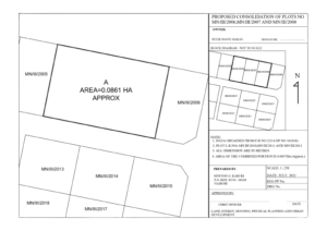
A consolidation survey is a combination of several land parcels into one. Once complete, the land is given a new legal description to correctly reflect the new parcel.
It entails re-mapping of two or more adjacent lots or parcels of land, combining them into one larger parcel. Once the survey work is completed, a map that indicates the new combined parcel of land will be reflected on the approved consolidation survey plan and marks the new legal boundary for the consolidated piece of land
The primary reason for a consolidation survey is to parcel off sections of land to meet specifications. As a result, these new legal descriptions must meet city and county standards. Once completed, they must then be filed by the property owner with the county for approval. The cost of the survey is different for each project. Examples that could affect the cost are included in the list below.
factors determining cost of consolidation survey
- The location, accessibility, and ruggedness of the parcel of land you want surveyed.
- The shape and size of the surveyed parcels of land.
- Seasonal variations in important features of the land such as leaf cover or ground markings.
- “Riparian Rights” or issues arising from properties along water
GeoRole Surveying, offers survey services in Kenya including that of consolidation and is ready to assist with your land surveying needs. Contact us today!
by Georole Ltd | May 12, 2023 | land survey
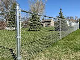
A boundary survey is an important component of property ownership and development. Typically, it is used to determine where property boundaries are located. This kind of survey is will define the corners of one’s property, sometimes described as a parcel of land, and will be accompanied by a drawing of the boundary lines from a boundary surveyor. Read more here.
Reasons behind boundary survey
- Buying property
- Dividing a parcel or parcels of land
- Adding improvements
- Before building on the property
Without a properly completed survey, it can lead to boundary disputes down the road. Therefore, it is imperative to recognize the importance of hiring a professional surveyor. GeoRole, offers survey services in Kenya including that of boundary and is ready to assist with your land surveying needs. Contact us today!
Our boundary survey process
Defining your property lines is the key objective for GeoRole Surveying. How do we do this?
- First, we review the county registry to locate any deeds for the property and surrounding properties.
- Second, we conduct research to locate documentation from previous land surveys, county offices, regional offices, ministry offices and historical societies.
- Third, and most important, we hit the ground for the survey. Each corner of the property is located and marked.
- Finally, we compile all of this information and complete the land survey and boundary survey drawing for the property.


