
by samson | Apr 28, 2023 | physical and land use planning, architectural, environnment management
Housing is a feature of Development Planning with focus on provisions of domestic shelter, residential facilities and utilities for families. A real home is defined as provision of shelter to protect the dwellers from elements of the weather with water and other services, security of tenure (land title) and safety, (UN declaration, IYSH-1987: International Year of Shelter for the Homeless).
Over the centuries, human societies have tackled the problem of providing the basic need of shelter in a variety of ways: by adapting to the natural environment and; by making use of the environmentally provided materials (local materials) for construction to give a “sheltered space”.
House
A house is a commodity, whose value is determined by what it can fetch in the market place [financial institutions]. The house owner uses the house as an expression of his aspirations and can be used as a collateral security to secure a loan or credit facility.
Housing
Refers to accommodation, structures or other buildings where people collectively live. Housing is the provision of permanent shelter for human habitation. Access to adequate housing or the provision of shelter is a basic need or fundamental or basic human right enshrined in the “Universal Declaration of Human Rights” and the International Covenant on Economic, Social and Cultural Rights”. Since Shelter provision is a basic need, i.e. necessary for everyone, the problem of providing adequate housing has long been the concern to individuals as well as governments Housing provision policies are specified for particular settlements and cannot be generalized. Itis relevant to cultural, social economic circumstances and environmental conditions and even sometimes, political issues.
Lack of housing is a manifestation of poverty. However, given the chance, the poor will wish to escape from their poverty situation by actively and innovatively seeking to improve their living conditions and livelihood. Decisions on housing provisions should be by participatory approach – the final decision on which kind of shelter to be provided must rest with the people concerned to meet their felt needs i.e. needs and priorities. The role of local government is to be a facilitator by providing appropriate regulations or guidelines and framework for housing development.
Objectives of housing provisions
Housing offers a complex mix of activities under one roof and in all this, the main purpose to be achieved includes the following:
- Protection from extremes of the climate e.g heat, humidity, rainfall, snow, dust and wind;
- for personal or group security;
- for promotion of social living: shelter provision supremely focuses on social living because humans are social creatures;
Housing Estate
A planned area of houses or apartment buildings, usually built at the same time to a similar design, sometimes with a number of small shops.
Housing Development
A planned area of houses or apartment buildings, usually built at the same time to a similar design, and managed by the same person or company
Low-Cost Housing Area [Housing Project]
A group of houses or apartment buildings built with public money for low-income earners or families.
Housing Scheme
A housing estate built by a local authority (if public housing scheme),originally made up of homes to be rented by public housing tenants, usually with subsidy.Housing schemes are not very popular in recent times.
Housing Association
An organization providing adequate housing or accommodation facilities.
Conclusion
The right to adequate housing is more than having a roof over one’s head, it is the right to live in safety and dignity in a decent home. This is charaterised by security, clean environment, affordable, access to basic utilities, ventilation, etc.

In case you find the article useful and would like to support me, you can buy me a coffee ☕

by Georole Ltd | Apr 25, 2023 | physical and land use planning
A planning appraisal is an assessment of the development potential of a site based on planning policy and other considerations.
Reasons why should carry out a planning appraisal
A planning appraisal may be carried out for a number of reasons including but not limited to:
- To assess whether a site is suitable for a specific development, or to identify alternative development options for a site in which you have an interest
- To establish the site-specific opportunities and constraints which will affect your decision-making process
- To distinguish between immediate and longer-term potential
- To identify additional information which may be needed for a final decision on whether to proceed
The appraisal should, as a matter of routine, cover site characteristics, planning history and relevant planning policy.
However, the key skill is to interpret this information. The following questions should provide a useful starting point.
Some Questions to Answer
- Is the proposal in accordance with the Development Plan, considering not only individual policies but the overall direction of the Plan?
- Should Local Plan policies be given reduced weight due to:
- Passage of time
- Changes in circumstances at the site
- Conflict with National Planning Policy Framework
- Current evidence of supply and demand for different types of land use
- Are there material considerations which would outweigh any policy conflict?
- Are there relevant permitted development rights available?
- Is site-specific evidence needed to support your case? (e.g. viability assessment)
- What opportunities and constraints arise from the site characteristics and what will their impact be on development capacity?
- How likely are current constraints to change with time? (e.g. regeneration initiatives which may improve viability, provision of new infrastructure)
- Was any refusal tested at appeal, can amendments address previous concerns or have circumstances changed?
The results
This framework provides a starting point, to be adapted to a specific proposal, site or user requirement. The outcome might range from a site being swiftly discounted to the production of a formal report to justify a site acquisition to the company board.
Recommendation

When providing a detailed appraisal, Georole Planning Team undertake research on a number of critical aspects that affect the development potential of a site.
Our experts understand the planning system, having experience assessing and promoting schemes and securing consents. Our expertise covers all types and scales of development. We use this expertise to review planning policy and decisions to advise on the prospects of development.
From this informed position we can advise on the potential development but most importantly the routes to achieving the required permissions. These options can include outline, full planning application and permitted development. This is the planning strategy to deliver the vision for the site.
The matters we cover in our appraisals:
- Existing lawful use
- Constraints
- Designations
- Planning history
- Current planning policy
- Emerging planning policy
- Strategic and national planning policy
- Permitted development
- Consenting options
- Community Infrastructure Levy
- Timescales
- External consultants
Therefore, if you want to call in expert help, you know where to come!
by Georole Ltd | Apr 22, 2023 | architectural, physical and land use planning
A building permit or construction permit is an official approval issued by government agency that allows you or your contractor to proceed with a construction or remodelling project on your property. It is intended to ensure that the project plans to comply with local standards for land use, zoning, and construction. These standards are intended to ensure the safety of current and future owners and occupants and to provide enforcement of zoning and land-use policies.
The specific issues that the building permit process may address include structural integrity of the framing work, zoning, sanitation, water, and sewer lines, fire protection, and electrical service.
The following is a list of the nine steps for obtaining a building permit in Kenya:
- Obtain a survey plan from Survey of Kenya
- Obtain a project report (Environmental and Social Impact Assessment) from an environmental expert
- Obtain approval of the environmental impact study from National Environment Management Authority (NEMA)
- Submit and obtain approval of the architectural plans from county government
- Submit and obtain approval of the structural plans
- Obtain stamps on architectural and structural plans from the Nairobi City County – Development Control Section
- Apply for project registration with the National Construction Authority (NCA)
- Receive on-site visits by NCA to check for compliance and obtain invoice
- Submit payment receipt, obtain preliminary compliance certificate and compliance certificate
Obtain a survey plan from Survey of Kenya
- Visit the Survey of Kenya offices in the ministry of land departments to obtain a survey plan. A survey plan from Survey of Kenya is a required document when applying for a building permit.
- Request for Folio Registry number search: You are required to provide proof of land ownership when requesting for the survey plan. One is shown the survey plan to confirm that it is the one they have requested for then issued with a payment authorization slip to go and pay for the survey plan.
- Proceed and pay for Folio Registry number search: You will be required to produce an authorisation of payment for this service. You will be charged Ksh 150 for the numbers search.
- Confirm availability of survey plan and Pay for survey plan: After the search is done and availability confirmed. You are to pay Ksh 650 for the survey plan.
- This process takes one day to complete.
Obtain a project report (Environmental and Social Impact Assessment) from an environmental expert
Once the survey plan has been obtained, a licensed environmental expert must be hired to prepare a project report to be submitted to NEMA.The project report can take a period of 3 to 5 days to complete.
Obtain approval of the environmental impact study from National Environment Management Authority (NEMA)
- Following the enactment of new Environmental Management and Co-ordination Act on February 27, 2009, companies now have to obtain approval of projects from the National Environment Management Authority (NEMA). Projects of all risk categories are subject to approval and an environmental impact assessment (EIA).
- It takes 30 days on average to get the approval. The cost is set at 0.05% of warehouse value, prior to February 11, 2009, the fee rate was 0.1% of warehouse value.
Submit and obtain approval of the architectural plans from county government
Submit architectural plans at the county development control office. The required documents to be submitted are the following:
- The proposed development
- A survey plan from Survey of Kenya
- Up-to-date rates payment receipts
- Structural plans
- Pay for permit fees: The County government will issue an invoice that must be paid, this can take up to 2-3 weeks to be obtained.
- Obtain architectural plans approval notification
- Submit architectural plans for signing
- The drawings are reviewed by all relevant departments simultaneously.
- When all signatures have been obtained, the approved plans are scanned and uploaded in the system so that they can be retrieved by the architect
- Obtain authenticated architectural plans and construction permit
- Building permit fee is based on the size of the building and varies from county to county depending on how its applied. e.g. some counties charge a specific amount per square meter.
Submit and obtain approval of the structural plans
- Visit the county’s development control office and follow the following steps:
- Submit structural plans

- Obtain structural plans approval notification
- Submit structural plans for signing
- Obtain authenticated structural plans
- With approved drawings, construction may start while the application for a building permit is being processed.
- The following documents are to be submitted for approval
- project plans
- architectural drawings
- Location survey of property documents and others.
- It takes approximately one day for approval.
Obtain stamps on architectural and structural plans from the Nairobi City County – Development Control Section
Once the plans have been approved, the architect must submit hard copies of the plans to be stamped by the County Government, even after submitting the documents online. The engineer must also do the same after the architect’s plans have been stamped. The engineer does not have to wait one month like the architect to bring in the hard copies.It takes approximately ten days for approval.
Apply for project registration with the National Construction Authority (NCA)
- The building company then has to register the proposed construction project with the National Construction Authority (NCA) and fill a project registration form providing details of the construction work. The Project registration form Can be downloaded from the NCA website
- It takes around a week to obtain the compliance certificate.
- Upon submission of the application, the building company receives a temporary certificate that testifies the registration is under process.
- The building company submits the project registration form to the authority with several documents listed below.
- Authenticated architectural plans (original)
- Authenticated structural plans (original)
- NEMA approval (Simple copy)
- Bill of quantities (Simple copy)
- contract/agreement (Simple copy) It should be duly signed by both the contractor and the client
- Contractor’s registration certificate (Simple copy)
- Quantity surveyor’s practicing certificate (Simple copy)
- Architect’s practicing certificate (Simple copy)
- Engineer’s practicing certificate (Simple copy)
- The building company will then be issued with an invoice on the amount of levy it should pay the authority at selected bank accounts, which are posted on the NCA website. The levy is 0.5% of the total cost of the project (percentage applicable to projects with a value of over Ksh.5,000,000).
- It takes approximately one day for approval. The approval is done free of charge.
Receive on-site visits by NCA to check for compliance and obtain invoice
- Once the application has been made, there is a site-inspection to check for compliance of the construction site against the approved plans and the NEMA clearance.
- After this site inspection, the applicant will receive an invoice showing the amount to be paid.
Submit payment receipt, obtain preliminary compliance certificate and compliance certificate
- Once payment is made, then a provisional certificate of compliance, valid for 90 days, is given to the applicant. If later, there are no violations of compliance, then the final compliance certificate will be issued
- It takes approximately seven days for approval.
“If you found this article helpful, consider supporting our work to keep creating valuable content.”

by Georole Ltd | Nov 11, 2022 | physical and land use planning
According to Kenyan laws and regulations, the proponent shall apply for and secure a permit of change of use before starting a development on his land or property for a purpose other than the permitted development as per the approved Zoning Regulations Plan or the existing physical development plan. Due to powers vested on County Governments to control land use and development, application is made to seek permit of change of use from the respective County Governments’ Department in charge of Physical Planning and urban development for consideration through a registered physical planner.
Procedure for securing permit of change of use
step 1
- Place an advertisement and get recommendations from members of the public and line ministries, which are obtained by the County Government.
- Obtain PLUPA 1 form and make application for the change of use by filling in the form and duly signed by a registered physical planner.
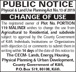 Publish public notices regarding the proposed change of use in two daily circulating newspapers, inviting objections from the public within a period of not less than fourteen days. A site notice will also be placed on the site indicating intention to change its use within the same duration.
- Through a physical planner prepare a Planning brief whose objectives include; to examine the compatibility of the proposed development with the development trend in the area, to provide background information regarding the site area in reference to the physical setting, location and level of infrastructure and services, to evaluate the impact of the proposed development on the socio-economic and physical environments in the area and to make appropriate recommendations in reference to the policies governing development and the level of compatibility of the development with the socio- economic environment and other land uses for consideration by the approving authorities.
- Pay the requisite fee to the respective County Government and annex the receipt to the planning brief.
- Submit the planning brief attached with the required documents to the County Government’s Department of Physical Planning for approval.
- The County Government will receives submissions from the general public on any oppositions to the change of use.
- The County Government will then review the change of use proposal/brief with the public objections received if any and will pass a resolution, recording reasons, regarding its consideration or non-consideration for the change.
- The authority shall, if it finds that the changes sought are relevant to planning principles and are in public interest and are not in contravention to any other statute, give permission for the same by issuing a PLUPA 2 form.
step 2
- An application is further made to the Commissioner of Lands for change of use;
- The Commissioner of Lands issues an approval/consent to effect change of use, subject to Banker’s Cheque payments towards Surrender (Conveyancing and registration) and Grant of New Title (Conveyancing, registration an stamp duty);
- The Consent from Commissioner of Lands is then forwarded together with all documents to Survey of Kenya to obtain deed plan;
- Surrender the title.
Requirements for application to secure permit of change of use
- Two Dully filled P.P.A 1 forms in triplicate submitted and signed by a Registered physical Planner
- Planning Brief prepared by a Registered Physical Planner (signed accordingly)
- Planning scheme
- Ownership documents: can either be a title deed, certificate of title or certificate of lease.
- Survey plan
- Comprehensive Location Plan
- Advertisement of proposal on two local dailies
- Application fee receipt
- Latest Rates payment receipts*
Professional & Statutory Costs involved in securing permit of change of use
1. The change of use application has no standard fee since it varies in counties depending on the sought of change
2. PLUPA 1 form fee is usually Kshs.1000
3. Newspaper Advertisements (Two daily newspapers)
4. Professional Fee depending on the project size and its locality.
Conclusion
Georole Ltd hopes that this article have sufficiently covered the procedure for securing a permit of change of use in Kenya. Should you however need further clarifications, we remain available for further consultation and to assist you professionally and efficiently to secure a permit of change of use. Reach our team of physical planners through here.
“If you found this article helpful, consider supporting our work to keep creating valuable content.”
by Georole Ltd | Nov 10, 2022 | land survey, physical and land use planning
(more…)

by Georole Ltd | Oct 21, 2022 | physical and land use planning
Definitions
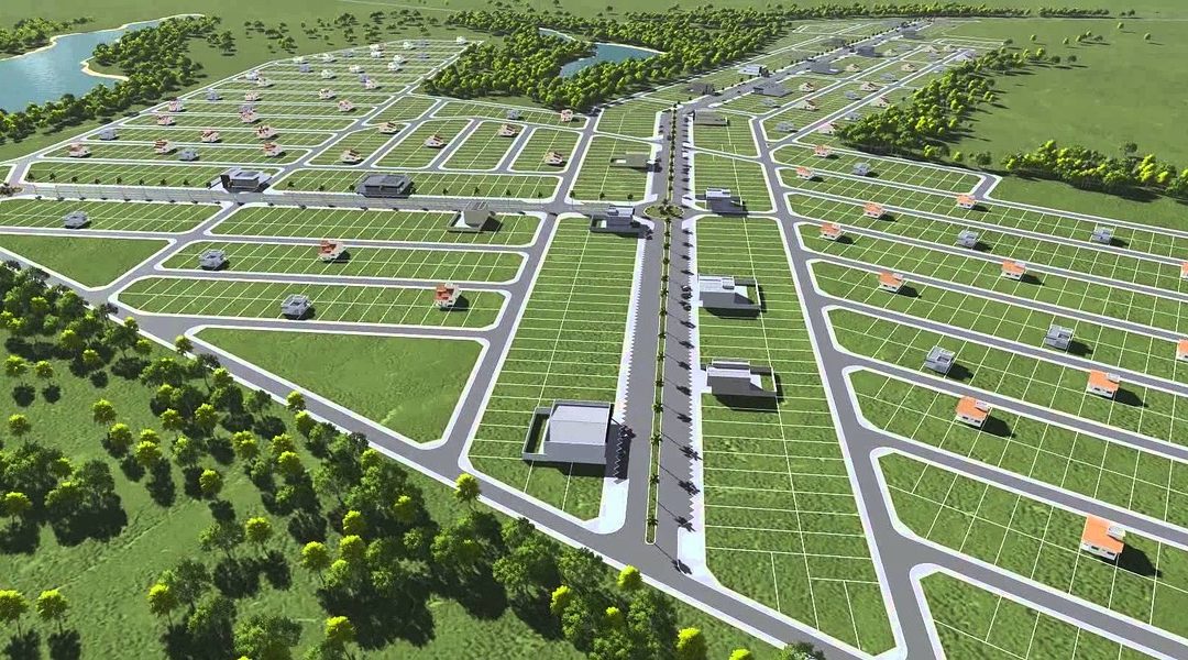
A Master Plan is an evolving long term perspective plan document which is a guide to the sustainable and planned development of an organization, a town or a city. The plan document entails planning guidelines, policies, spatial needs and development plans for various socio-economic activities such as housing, transportation, community facilities etc. that support the population.
A master plan is a blueprint for the future growth of any organization and must be directly tied to the core business goals and planning. It will identify economic and other factors such as utility infrastructure development, planning, acquisition and sustainability.
A Master plan is a type of a plan that pertains to the physical development of a city, town or municipality over the long term that ranges between 10 to 15 years into the future. It is intended to guide a community’s growth from a high-level perspective, focusing on:
- Building and preserving a locality’s unique character
- Diversity
- Investment
- Desired change
- Enhance livability of a community
Note: Master plans are aspirational i.e., they imagine what’s possible and propose a direction to achieve those goals. But that doesn’t mean they are permanent. Circumstances may change as time goes on, and plans may need to be adjusted accordingly.
Importance of a master plan
The approach of a master plan provides the foundation for:
- The long-term investment plans
- The development of physical assets
- The evaluation of regulations, including zoning standards
- The identification of areas in need of utility development or extensions
- The acquisition and development of future facility sites
- The incorporation of environmental conservation and sustainability features
- The prioritization of overall needs
Process of preparing a master plan
- Public participation: ask the public about their vision and questions that will prompt them to reflect on the town’s character as well as their thoughts on the future. The goal of this step is to create community-supported vision statements, goals, and objectives that will help guide the development of your master plan.
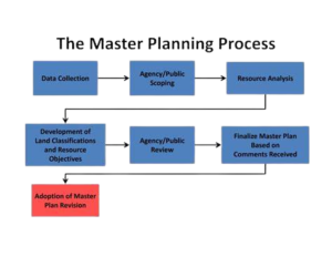
- Relevant data collection and analysis: gather data that is likely to influence the priorities and projects identified in the master plan. this step enables you to understand the current state and identify possible future conditions that might drive the need for specific changes.
- Identify alternatives: by employing what you have learnt about current state, future projections, land maps, and community input, consider a variety of development scenarios
- Narrow down alternatives: Compare the advantages and disadvantages of each alternative, and how you can best use your current land and resources to encourage your preferred type of growth. Note that to eliminate options, you may need to develop a set of criteria to measure each scenario against.
- Prepare a strategy of moving forward: Once a development scenario is decided, form a strategy as to how, when, and by whom the recommendations of the plan should be implemented. As board and committee members in all functional areas consider proposed projects in the months and years ahead, how will you ensure that development aligns with goals and drives progress forward in the intended way?
- Manage and track project/program performance: monitor the plan’s progress over time to make sure it is heading in the right direction.
- Goals and policies: these are the desires and wishes about what kind of place it wants to be and how it wants to improve its quality of life.
- land use: Looks at the pattern of land use.
- housing: considers the pattern of residential development in determining what types of housing stock is needed and where it might best be constructed in the future as well as assessing the locality how future market forces may influence the development and affordability of housing
- Economic development: determines the strengths and weaknesses of the labor force and market sectors in the local economy in planning for new business and development.
- natural resources: identifies land, water, cultural and historic resources whose preservation is important in maintaining natural resources and the character.
- open space and recreation: assess the future recreational needs in planning for the maintenance and expansion of existing areas, and the construction of new facilities
- services and facilities
- transportation and circulation
- implementation
Recommendations
The process of preparing a master plan requires to involve professional experts such as Planners, architects and Surveyors with experience in this area.
In case you find the article useful and would like to support me, you can buy me a coffee ☕